Sokna geodata
Sokna (Buskerud) is a populated place; located in Norway in Europe/Oslo (GMT+2) time zone. With population of 543 people, there are 447 cities with bigger population in this country. Compared to other cities in Norway, 59% of cities are located further ↑North; 52.4% of cities are located further →East and 73.9% of cities have lower elevation than Sokna. Note1


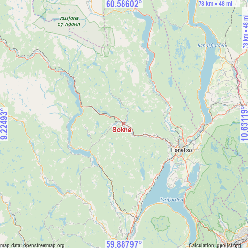
Sokna GPS coordinates[2]
60° 14' 19.86" North, 9° 55' 41.016" East
| Map corner | latitude | longitude |
|---|---|---|
| Upper-left | 60.58602°, | 9.22493° |
| Center: | 60.23885°, | 9.92806° |
| Lower-right: | 59.88797°, | 10.63119° |
| Map W x H: | 77.6×77.6 km | = 48.2×48.2mi |
| max Lat: | 71.04137° ⇑59% North |
| Sokna: | 60.23885° |
| min Lat: | ⇓41% South 58.0274° |
| min Long | Sokna | max Long |
| 4.71485° | 9.92806° | 31.11066° |
| W 47.6%⇐ | ⇒52.4% E |
Elevation
Elevation of Sokna is 140 m = 459 ft, and this is 35.8 m = 117 ft above average elevation for this country.
| Max E: |
897 m = 2943 ft | 26.1% |
| Sokna | 140 m 459 ft | |
| Avg. | 104.2 m = 342 ft | |
Min E: |
1 m = 3 ft | 73.9% |
See also: Norway elevation on elevation.city.
Geographical zone
Sokna is located in North temperate zone (between Tropic of Cancer and the Arctic Circle). Distance of this North polar circle is 703.2 km =436.9 mi to North.| Distance of | km | miles | from Sokna |
|---|---|---|---|
| North Pole | 3309.1 | 2056.2 | to North |
| Arctic Circle | 703.2 | 436.9 | to North |
| Tropic Cancer | 4092 | 2542.7 | to South |
| Equator | 6697.9 | 4161.9 | to South |


Nearby cities:
15 places around Sokna: (largest is in red/bold)
• Flå
33.3 km =20.7 mi,  309°
309°
• Grua
40.6 km =25.2 mi,  87°
87°
• Hallingby
14.6 km =9.1 mi,  75°
75°
• Hønefoss
19.8 km =12.3 mi,  113°
113°
• Jaren
38.9 km =24.2 mi,  63°
63°
• Jevnaker
25.3 km =15.7 mi, 89°
• Noresund
18 km =11.2 mi,  248°
248°
• Prestfoss
27.1 km =16.8 mi,  216°
216°
• Roa
38.4 km =23.9 mi, 81°
• Smestad
44 km =27.3 mi,  140°
140°
• Sundvollen
28.7 km =17.8 mi,  133°
133°
• Sylling
43.4 km =27 mi,  152°
152°
• Tyristrand
19.4 km =12.1 mi, 151°
• Vik
26.5 km =16.5 mi, 132°
• Vikersund
30.3 km =18.8 mi,  173°
173°
Sources, notices
• [Note1] Compared only with cities in Norway existing in our database
• [Src1] Map data: © OpenStreetMap contributors (CC-BY-SA)
• [Src2] Other city data from geonames.org with taken over terms of usage.
• [Src3] Geographical zone / Annual Mean Temperature by Robert A. Rohde @ Wikipedia
