Segalstad bru geodata
Segalstad bru (Oppland) is a seat of a second-order administrative division; located in Norway in Europe/Oslo (GMT+2) time zone. In our database, there are 488 cities with bigger population. Compared to other cities in Norway, 58.4% of cities are located further ↓South; 51.1% of cities are located further ←West and 91.6% of cities have lower elevation than Segalstad bru. Note1


Segalstad bru GPS coordinates[2]
61° 13' 41.484" North, 10° 13' 21.18" East
| Map corner | latitude | longitude |
|---|---|---|
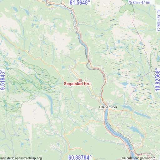
| Upper-left | 61.5648°, | 9.51943° |
| Center: | 61.22819°, | 10.22255° |
| Lower-right: | 60.88794°, | 10.92568° |
| Map W x H: | 75.3×75.3 km | = 46.8×46.8mi |
| max Lat: | 71.04137° ⇑41.6% North |
| Segalstad bru: | 61.22819° |
| min Lat: | ⇓58.4% South 58.0274° |
| min Long | Segalstad bru | max Long |
| 4.71485° | 10.22255° | 31.11066° |
| W 51.1%⇐ | ⇒48.9% E |
Elevation
Elevation of Segalstad bru is 320 m = 1050 ft, and this is 215.8 m = 708 ft above average elevation for this country.
| Max E: |
897 m = 2943 ft | 8.4% |
| Segalstad bru | 320 m 1050 ft | |
| Avg. | 104.2 m = 342 ft | |
Min E: |
1 m = 3 ft | 91.6% |
See also: Norway elevation on elevation.city.
Geographical zone
Segalstad bru is located in North temperate zone (between Tropic of Cancer and the Arctic Circle). Distance of this North polar circle is 593.2 km =368.6 mi to North.| Distance of | km | miles | from Segalstad bru |
|---|---|---|---|
| North Pole | 3199.1 | 1987.8 | to North |
| Arctic Circle | 593.2 | 368.6 | to North |
| Tropic Cancer | 4202 | 2611 | to South |
| Equator | 6807.9 | 4230.2 | to South |


Nearby cities:
15 places around Segalstad bru: (largest is in red/bold)
• Aurdal
55 km =34.2 mi,  232°
232°
• Bruflat
49.1 km =30.5 mi,  219°
219°
• Brumunddal
54.6 km =33.9 mi,  135°
135°
• Dokka
44.4 km =27.6 mi,  190°
190°
• Follebu
3.6 km =2.2 mi,  112°
112°
• Forset
5.1 km =3.2 mi,  235°
235°
• Gjøvik
54.3 km =33.7 mi,  152°
152°
• Hundorp
39.3 km =24.4 mi,  337°
337°
• Kvam
56.3 km =35 mi,  329°
329°
• Lillehammer
18.1 km =11.2 mi,  133°
133°
• Moelv
41.6 km =25.8 mi, 141°
• Ringebu
33.8 km =21 mi,  352°
352°
• Segalstad
0.8 km =0.5 mi,  45°
45°
• Tretten
10.4 km =6.5 mi,  23°
23°
• Vinstra
47.9 km =29.8 mi, 328°
Sources, notices
• [Note1] Compared only with cities in Norway existing in our database
• [Src1] Map data: © OpenStreetMap contributors (CC-BY-SA)
• [Src2] Other city data from geonames.org with taken over terms of usage.
• [Src3] Geographical zone / Annual Mean Temperature by Robert A. Rohde @ Wikipedia
