Forset geodata
Forset (Oppland) is a populated place; located in Norway in Europe/Oslo (GMT+2) time zone. With population of 637 people, there are 404 cities with bigger population in this country. Compared to other cities in Norway, 57.6% of cities are located further ↓South; 50.2% of cities are located further ←West and 91.6% of cities have lower elevation than Forset. Note1


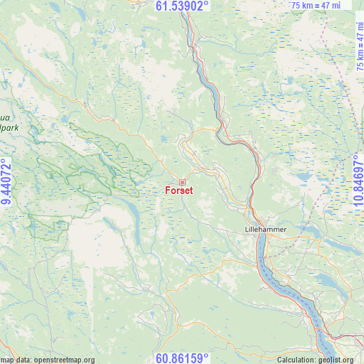
Forset GPS coordinates[2]
61° 12' 7.668" North, 10° 8' 37.824" East
| Map corner | latitude | longitude |
|---|---|---|
| Upper-left | 61.53902°, | 9.44072° |
| Center: | 61.20213°, | 10.14384° |
| Lower-right: | 60.86159°, | 10.84697° |
| Map W x H: | 75.3×75.3 km | = 46.8×46.8mi |
| max Lat: | 71.04137° ⇑42.4% North |
| Forset: | 61.20213° |
| min Lat: | ⇓57.6% South 58.0274° |
| min Long | Forset | max Long |
| 4.71485° | 10.14384° | 31.11066° |
| W 50.2%⇐ | ⇒49.8% E |
Elevation
Elevation of Forset is 320 m = 1050 ft, and this is 215.8 m = 708 ft above average elevation for this country.
| Max E: |
897 m = 2943 ft | 8.4% |
| Forset | 320 m 1050 ft | |
| Avg. | 104.2 m = 342 ft | |
Min E: |
1 m = 3 ft | 91.6% |
See also: Norway elevation on elevation.city.
Geographical zone
Forset is located in North temperate zone (between Tropic of Cancer and the Arctic Circle). Distance of this North polar circle is 596.1 km =370.4 mi to North.| Distance of | km | miles | from Forset |
|---|---|---|---|
| North Pole | 3202 | 1989.6 | to North |
| Arctic Circle | 596.1 | 370.4 | to North |
| Tropic Cancer | 4199.1 | 2609.2 | to South |
| Equator | 6805 | 4228.4 | to South |


Nearby cities:
15 places around Forset: (largest is in red/bold)
• Aurdal
49.9 km =31 mi,  231°
231°
• Bagn
52.9 km =32.9 mi,  217°
217°
• Bruflat
44.2 km =27.5 mi, 217°
• Dokka
41 km =25.5 mi,  185°
185°
• Follebu
7.7 km =4.8 mi,  78°
78°
• Gjøvik
54 km =33.6 mi,  146°
146°
• Hundorp
40.7 km =25.3 mi,  344°
344°
• Leira
52.4 km =32.6 mi,  240°
240°
• Lillehammer
19.8 km =12.3 mi,  119°
119°
• Moelv
42.3 km =26.3 mi,  134°
134°
• Ringebu
36.4 km =22.6 mi,  359°
359°
• Segalstad
5.9 km =3.7 mi,  54°
54°
• Segalstad bru
5.1 km =3.2 mi,  55°
55°
• Tretten
15 km =9.3 mi,  33°
33°
• Vinstra
48.4 km =30.1 mi,  334°
334°
Sources, notices
• [Note1] Compared only with cities in Norway existing in our database
• [Src1] Map data: © OpenStreetMap contributors (CC-BY-SA)
• [Src2] Other city data from geonames.org with taken over terms of usage.
• [Src3] Geographical zone / Annual Mean Temperature by Robert A. Rohde @ Wikipedia
