Gryllefjord geodata
Gryllefjord (Troms) is a seat of a second-order administrative division; located in Norway in Europe/Oslo (GMT+2) time zone. With population of 439 people, there are 469 cities with bigger population in this country. Compared to other cities in Norway, 95.6% of cities are located further ↓South; 92.7% of cities are located further ←West and 100% of cities have higher elevation than Gryllefjord. Note1


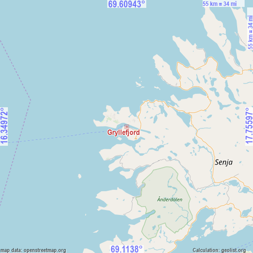
Gryllefjord GPS coordinates[2]
69° 21' 46.944" North, 17° 3' 10.224" East
| Map corner | latitude | longitude |
|---|---|---|
| Upper-left | 69.60943°, | 16.34972° |
| Center: | 69.36304°, | 17.05284° |
| Lower-right: | 69.1138°, | 17.75597° |
| Map W x H: | 55.1×55.1 km | = 34.2×34.2mi |
| max Lat: | 71.04137° ⇑4.4% North |
| Gryllefjord: | 69.36304° |
| min Lat: | ⇓95.6% South 58.0274° |
| min Long | Gryllefjord | max Long |
| 4.71485° | 17.05284° | 31.11066° |
| W 92.7%⇐ | ⇒7.3% E |
Elevation
Elevation of Gryllefjord is 1 m = 3 ft, and this is 103.2 m = 339 ft below average elevation for this country.
| Max E: |
897 m = 2943 ft | 100% |
| Avg. | 104.2 m = 342 ft | |
| Gryllefjord | 1 m = 3 ft | |
Min E: |
1 m = 3 ft | 0% |
See also: Norway elevation on elevation.city.
Geographical zone
Gryllefjord is located in North Frigid zone (between North Pole and Arctic Circle). Distance of this North polar circle is 311.3 km =193.4 mi to South.| Distance of | km | miles | from Gryllefjord |
|---|---|---|---|
| North Pole | 2294.6 | 1425.8 | to North |
| Arctic Circle | 311.3 | 193.4 | to South |
| Tropic Cancer | 5106.5 | 3173 | to South |
| Equator | 7712.4 | 4792.3 | to South |


Nearby cities:
15 places around Gryllefjord: (largest is in red/bold)
• Andenes
37 km =23 mi,  261°
261°
• Andselv
66.5 km =41.3 mi,  119°
119°
• Borkenes
74.4 km =46.2 mi,  208°
208°
• Brøstadbotn
39.6 km =24.6 mi,  140°
140°
• Finnsnes
39.4 km =24.5 mi,  112°
112°
• Hamnvik
65.1 km =40.5 mi,  175°
175°
• Harstad
66 km =41 mi,  197°
197°
• Moen
66.7 km =41.4 mi, 112°
• Myre
51.6 km =32.1 mi,  236°
236°
• Setermoen
75.9 km =47.2 mi, 137°
• Sjøvegan
62.9 km =39.1 mi,  149°
149°
• Skaland
13.2 km =8.2 mi,  46°
46°
• Sørreisa
49.6 km =30.8 mi, 119°
• Tennevoll
74.7 km =46.4 mi,  156°
156°
• Vangsvika
34.3 km =21.3 mi,  128°
128°
Sources, notices
• [Note1] Compared only with cities in Norway existing in our database
• [Src1] Map data: © OpenStreetMap contributors (CC-BY-SA)
• [Src2] Other city data from geonames.org with taken over terms of usage.
• [Src3] Geographical zone / Annual Mean Temperature by Robert A. Rohde @ Wikipedia
