Chame geodata
Chame (Western Region) is a seat of a fourth-order administrative division; located in Nepal in Asia/Kathmandu (GMT+5.75) time zone. In our database, there are 62 cities with bigger population. Compared to other cities in Nepal, 79.7% of cities are located further ↓South; 52.7% of cities are located further →East and 90.5% of cities have lower elevation than Chame. Note1
Administrative division(s):
- Level 1: Western Region
- Level 2: Gandakī Zone
- Level 3: Manang
- Level 4: Chame


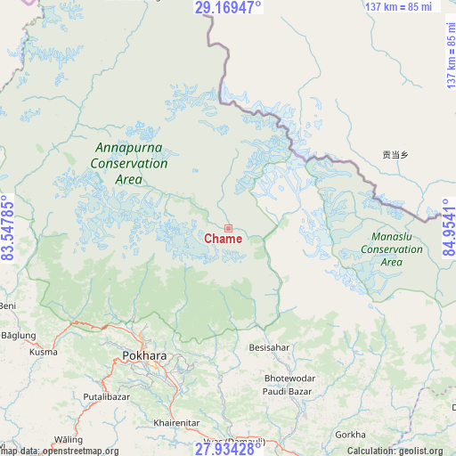
Chame GPS coordinates[2]
28° 33' 13.284" North, 84° 15' 3.492" East
| Map corner | latitude | longitude |
|---|---|---|
| Upper-left | 29.16947°, | 83.54785° |
| Center: | 28.55369°, | 84.25097° |
| Lower-right: | 27.93428°, | 84.9541° |
| Map W x H: | 137.3×137.3 km | = 85.3×85.3mi |
| max Lat: | 30.04651° ⇑20.3% North |
| Chame: | 28.55369° |
| min Lat: | ⇓79.7% South 26.45505° |
| min Long | Chame | max Long |
| 80.17715° | 84.25097° | 88.09436° |
| W 47.3%⇐ | ⇒52.7% E |
Elevation
Elevation of Chame is 2870 m = 9416 ft, and this is 1694.8 m = 5560 ft above average elevation for this country.
| Max E: |
5251 m = 17228 ft | 9.5% |
| Chame | 2870 m 9416 ft | |
| Avg. | 1175.2 m = 3856 ft | |
Min E: |
72 m = 236 ft | 90.5% |
See also: Nepal elevation on elevation.city.
Geographical zone
Chame is located in North temperate zone (between Tropic of Cancer and the Arctic Circle). Distance of this Northern Tropic circle is 569 km =353.6 mi to South.| Distance of | km | miles | from Chame |
|---|---|---|---|
| North Pole | 6832.2 | 4245.3 | to North |
| Arctic Circle | 4226.3 | 2626.1 | to North |
| Tropic Cancer | 569 | 353.6 | to South |
| Equator | 3174.9 | 1972.8 | to South |


Nearby cities:
15 places around Chame: (largest is in red/bold)
• Bharatpur
99.2 km =61.6 mi,  169°
169°
• Bhattarai Danda
80.8 km =50.2 mi,  202°
202°
• Butwāl
123.3 km =76.6 mi,  219°
219°
• Bāglung
71.9 km =44.7 mi,  244°
244°
• Chitre
56.5 km =35.1 mi,  255°
255°
• Dihi
81.8 km =50.8 mi, 202°
• Jomsom
56.5 km =35.1 mi,  297°
297°
• Khudi
32 km =19.9 mi,  160°
160°
• Lamjung
39.8 km =24.7 mi, 163°
• Nawal
17.9 km =11.1 mi,  306°
306°
• Pisang
12.2 km =7.6 mi, 303°
• Pokhara
42.2 km =26.2 mi, 220°
• Sundar Basti
80.8 km =50.2 mi, 202°
• Tānsen
102.9 km =63.9 mi, 222°
• Wāliṅ
79.6 km =49.5 mi, 217°
Sources, notices
• [Note1] Compared only with cities in Nepal existing in our database
• [Src1] Map data: © OpenStreetMap contributors (CC-BY-SA)
• [Src2] Other city data from geonames.org with taken over terms of usage.
• [Src3] Geographical zone / Annual Mean Temperature by Robert A. Rohde @ Wikipedia
