Jomsom geodata
Jomsom (Western Region) is a seat of a fourth-order administrative division; located in Nepal in Asia/Kathmandu (GMT+5.75) time zone. In our database, there are 62 cities with bigger population. Compared to other cities in Nepal, 86.5% of cities are located further ↓South; 63.5% of cities are located further →East and 89.2% of cities have lower elevation than Jomsom. Note1
Administrative division(s):
- Level 1: Western Region
- Level 2: Dhawalāgiri Zone
- Level 3: Mustāng
- Level 4: Jomsom


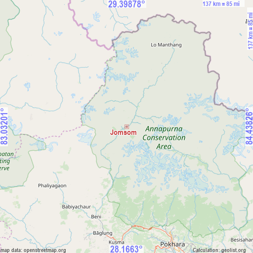
Jomsom GPS coordinates[2]
28° 47' 3.696" North, 83° 44' 6.468" East
| Map corner | latitude | longitude |
|---|---|---|
| Upper-left | 29.39878°, | 83.03201° |
| Center: | 28.78436°, | 83.73513° |
| Lower-right: | 28.1663°, | 84.43826° |
| Map W x H: | 137×137 km | = 85.1×85.1mi |
| max Lat: | 30.04651° ⇑13.5% North |
| Jomsom: | 28.78436° |
| min Lat: | ⇓86.5% South 26.45505° |
| min Long | Jomsom | max Long |
| 80.17715° | 83.73513° | 88.09436° |
| W 36.5%⇐ | ⇒63.5% E |
Elevation
Elevation of Jomsom is 2752 m = 9029 ft, and this is 1576.8 m = 5173 ft above average elevation for this country.
| Max E: |
5251 m = 17228 ft | 10.8% |
| Jomsom | 2752 m 9029 ft | |
| Avg. | 1175.2 m = 3856 ft | |
Min E: |
72 m = 236 ft | 89.2% |
See also: Nepal elevation on elevation.city.
Geographical zone
Jomsom is located in North temperate zone (between Tropic of Cancer and the Arctic Circle). Distance of this Northern Tropic circle is 594.6 km =369.5 mi to South.| Distance of | km | miles | from Jomsom |
|---|---|---|---|
| North Pole | 6806.5 | 4229.4 | to North |
| Arctic Circle | 4200.7 | 2610.2 | to North |
| Tropic Cancer | 594.6 | 369.5 | to South |
| Equator | 3200.5 | 1988.7 | to South |


Nearby cities:
15 places around Jomsom: (largest is in red/bold)
• Bhattarai Danda
102 km =63.4 mi,  169°
169°
• Butwāl
123.7 km =76.9 mi,  193°
193°
• Bāglung
58.7 km =36.5 mi, 193°
• Chame
56.5 km =35.1 mi,  117°
117°
• Chitre
40 km =24.9 mi, 186°
• Dihi
102.8 km =63.9 mi, 169°
• Khudi
82.7 km =51.4 mi,  132°
132°
• Lamjung
88.6 km =55.1 mi,  136°
136°
• Nawal
38.9 km =24.2 mi,  112°
112°
• Pisang
44.4 km =27.6 mi, 115°
• Pokhara
61.9 km =38.5 mi,  158°
158°
• Pyūthān
113.6 km =70.6 mi,  227°
227°
• Sundar Basti
102.1 km =63.4 mi, 169°
• Tānsen
103.6 km =64.4 mi, 190°
• Wāliṅ
89.1 km =55.4 mi,  178°
178°
Sources, notices
• [Note1] Compared only with cities in Nepal existing in our database
• [Src1] Map data: © OpenStreetMap contributors (CC-BY-SA)
• [Src2] Other city data from geonames.org with taken over terms of usage.
• [Src3] Geographical zone / Annual Mean Temperature by Robert A. Rohde @ Wikipedia
