Lamjung geodata
Lamjung (Western Region) is a seat of a third-order administrative division; located in Nepal in Asia/Kathmandu (GMT+5.75) time zone. In our database, there are 62 cities with bigger population. Compared to other cities in Nepal, 66.2% of cities are located further ↓South; 50% of cities are located further ←West and 68.9% of cities have lower elevation than Lamjung. Note1


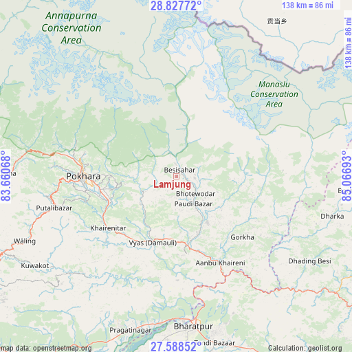
Lamjung GPS coordinates[2]
28° 12' 35.712" North, 84° 21' 49.68" East
| Map corner | latitude | longitude |
|---|---|---|
| Upper-left | 28.82772°, | 83.66068° |
| Center: | 28.20992°, | 84.3638° |
| Lower-right: | 27.58852°, | 85.06693° |
| Map W x H: | 137.8×137.8 km | = 85.6×85.6mi |
| max Lat: | 30.04651° ⇑33.8% North |
| Lamjung: | 28.20992° |
| min Lat: | ⇓66.2% South 26.45505° |
| min Long | Lamjung | max Long |
| 80.17715° | 84.3638° | 88.09436° |
| W 50%⇐ | ⇒50% E |
Elevation
Elevation of Lamjung is 1420 m = 4659 ft, and this is 244.8 m = 803 ft above average elevation for this country.
| Max E: |
5251 m = 17228 ft | 31.1% |
| Lamjung | 1420 m 4659 ft | |
| Avg. | 1175.2 m = 3856 ft | |
Min E: |
72 m = 236 ft | 68.9% |
See also: Nepal elevation on elevation.city.
Geographical zone
Lamjung is located in North temperate zone (between Tropic of Cancer and the Arctic Circle). Distance of this Northern Tropic circle is 530.7 km =329.8 mi to South.| Distance of | km | miles | from Lamjung |
|---|---|---|---|
| North Pole | 6870.4 | 4269.1 | to North |
| Arctic Circle | 4264.5 | 2649.8 | to North |
| Tropic Cancer | 530.7 | 329.8 | to South |
| Equator | 3136.6 | 1949 | to South |


Nearby cities:
15 places around Lamjung: (largest is in red/bold)
• Bharatpur
59.7 km =37.1 mi,  173°
173°
• Bhattarai Danda
55.7 km =34.6 mi,  229°
229°
• Butwāl
106.3 km =66.1 mi,  237°
237°
• Bāglung
76.1 km =47.3 mi,  275°
275°
• Chame
39.8 km =24.7 mi,  343°
343°
• Chitre
70.2 km =43.6 mi,  290°
290°
• Dihi
56.7 km =35.2 mi, 229°
• Jomsom
88.6 km =55.1 mi,  316°
316°
• Khudi
8 km =5 mi,  356°
356°
• Nawal
55 km =34.2 mi,  332°
332°
• Pisang
49.7 km =30.9 mi, 334°
• Pokhara
39.2 km =24.4 mi, 279°
• Sundar Basti
55.8 km =34.7 mi, 229°
• Tānsen
88.8 km =55.2 mi, 244°
• Wāliṅ
64.4 km =40 mi,  247°
247°
Sources, notices
• [Note1] Compared only with cities in Nepal existing in our database
• [Src1] Map data: © OpenStreetMap contributors (CC-BY-SA)
• [Src2] Other city data from geonames.org with taken over terms of usage.
• [Src3] Geographical zone / Annual Mean Temperature by Robert A. Rohde @ Wikipedia
