Chitre geodata
Chitre (Western Region) is a populated place; located in Nepal in Asia/Kathmandu (GMT+5.75) time zone. With population of 2,860 people, there are 52 cities with bigger population in this country. Compared to other cities in Nepal, 75.7% of cities are located further ↓South; 64.9% of cities are located further →East and 86.5% of cities have lower elevation than Chitre. Note1


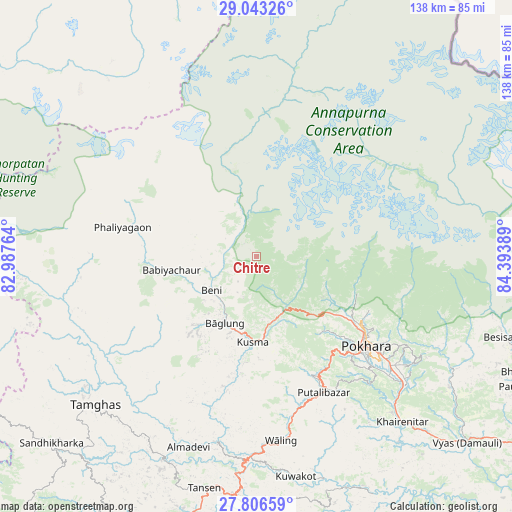
Chitre GPS coordinates[2]
28° 25' 36.228" North, 83° 41' 26.736" East
| Map corner | latitude | longitude |
|---|---|---|
| Upper-left | 29.04326°, | 82.98764° |
| Center: | 28.42673°, | 83.69076° |
| Lower-right: | 27.80659°, | 84.39389° |
| Map W x H: | 137.5×137.5 km | = 85.4×85.4mi |
| max Lat: | 30.04651° ⇑24.3% North |
| Chitre: | 28.42673° |
| min Lat: | ⇓75.7% South 26.45505° |
| min Long | Chitre | max Long |
| 80.17715° | 83.69076° | 88.09436° |
| W 35.1%⇐ | ⇒64.9% E |
Elevation
Elevation of Chitre is 2311 m = 7582 ft, and this is 1135.8 m = 3726 ft above average elevation for this country.
| Max E: |
5251 m = 17228 ft | 13.5% |
| Chitre | 2311 m 7582 ft | |
| Avg. | 1175.2 m = 3856 ft | |
Min E: |
72 m = 236 ft | 86.5% |
See also: Nepal elevation on elevation.city.
Geographical zone
Chitre is located in North temperate zone (between Tropic of Cancer and the Arctic Circle). Distance of this Northern Tropic circle is 554.8 km =344.7 mi to South.| Distance of | km | miles | from Chitre |
|---|---|---|---|
| North Pole | 6846.3 | 4254.1 | to North |
| Arctic Circle | 4240.4 | 2634.9 | to North |
| Tropic Cancer | 554.8 | 344.7 | to South |
| Equator | 3160.8 | 1964 | to South |


Nearby cities:
15 places around Chitre: (largest is in red/bold)
• Bhattarai Danda
64.9 km =40.3 mi,  158°
158°
• Butwāl
84.2 km =52.3 mi,  196°
196°
• Bāglung
19.9 km =12.4 mi,  209°
209°
• Chame
56.5 km =35.1 mi,  75°
75°
• Dihi
65.5 km =40.7 mi, 159°
• Jomsom
40 km =24.9 mi,  6°
6°
• Khudi
67.3 km =41.8 mi,  103°
103°
• Lamjung
70.2 km =43.6 mi,  110°
110°
• Nawal
47.2 km =29.3 mi,  58°
58°
• Pisang
49.2 km =30.6 mi, 64°
• Pokhara
32.5 km =20.2 mi,  123°
123°
• Pyūthān
87.5 km =54.4 mi,  244°
244°
• Sundar Basti
64.9 km =40.3 mi, 158°
• Tānsen
63.8 km =39.6 mi,  192°
192°
• Wāliṅ
49.7 km =30.9 mi,  172°
172°
Sources, notices
• [Note1] Compared only with cities in Nepal existing in our database
• [Src1] Map data: © OpenStreetMap contributors (CC-BY-SA)
• [Src2] Other city data from geonames.org with taken over terms of usage.
• [Src3] Geographical zone / Annual Mean Temperature by Robert A. Rohde @ Wikipedia
