Pyūthān geodata
Pyūthān (Mid Western) is a seat of a third-order administrative division; located in Nepal in Asia/Kathmandu (GMT+5.75) time zone. In our database, there are 62 cities with bigger population. Compared to other cities in Nepal, 62.2% of cities are located further ↓South; 71.6% of cities are located further →East and 63.5% of cities have lower elevation than Pyūthān. Note1


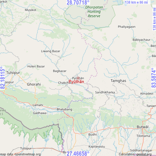
Pyūthān GPS coordinates[2]
28° 5' 19.212" North, 82° 53' 3.372" East
| Map corner | latitude | longitude |
|---|---|---|
| Upper-left | 28.70718°, | 82.18115° |
| Center: | 28.08867°, | 82.88427° |
| Lower-right: | 27.46658°, | 83.5874° |
| Map W x H: | 137.9×137.9 km | = 85.7×85.7mi |
| max Lat: | 30.04651° ⇑37.8% North |
| Pyūthān: | 28.08867° |
| min Lat: | ⇓62.2% South 26.45505° |
| min Long | Pyūthān | max Long |
| 80.17715° | 82.88427° | 88.09436° |
| W 28.4%⇐ | ⇒71.6% E |
Elevation
Elevation of Pyūthān is 1336 m = 4383 ft, and this is 160.8 m = 528 ft above average elevation for this country.
| Max E: |
5251 m = 17228 ft | 36.5% |
| Pyūthān | 1336 m 4383 ft | |
| Avg. | 1175.2 m = 3856 ft | |
Min E: |
72 m = 236 ft | 63.5% |
See also: Nepal elevation on elevation.city.
Geographical zone
Pyūthān is located in North temperate zone (between Tropic of Cancer and the Arctic Circle). Distance of this Northern Tropic circle is 517.2 km =321.4 mi to South.| Distance of | km | miles | from Pyūthān |
|---|---|---|---|
| North Pole | 6883.9 | 4277.5 | to North |
| Arctic Circle | 4278 | 2658.2 | to North |
| Tropic Cancer | 517.2 | 321.4 | to South |
| Equator | 3123.2 | 1940.7 | to South |


Nearby cities:
15 places around Pyūthān: (largest is in red/bold)
• Besisahar
49 km =30.4 mi,  289°
289°
• Bhattarai Danda
105.5 km =65.6 mi,  102°
102°
• Bhojpur
110.2 km =68.5 mi,  261°
261°
• Butwāl
70.3 km =43.7 mi,  127°
127°
• Bāglung
72.1 km =44.8 mi,  73°
73°
• Chitre
87.5 km =54.4 mi,  64°
64°
• Dihi
105.1 km =65.3 mi, 103°
• Jomsom
113.6 km =70.6 mi,  47°
47°
• Pokhara
108.1 km =67.2 mi,  79°
79°
• Salyān
77 km =47.8 mi, 294°
• Siddharthanagar
85.9 km =53.4 mi,  139°
139°
• Sundar Basti
105.5 km =65.6 mi, 102°
• Tulsīpur
57.8 km =35.9 mi,  274°
274°
• Tānsen
69.5 km =43.2 mi,  110°
110°
• Wāliṅ
86.7 km =53.9 mi, 97°
Sources, notices
• [Note1] Compared only with cities in Nepal existing in our database
• [Src1] Map data: © OpenStreetMap contributors (CC-BY-SA)
• [Src2] Other city data from geonames.org with taken over terms of usage.
• [Src3] Geographical zone / Annual Mean Temperature by Robert A. Rohde @ Wikipedia
