Siraha geodata
Siraha (Eastern Region) is a populated place; located in Nepal in Asia/Kathmandu (GMT+5.75) time zone. With population of 24,657 people, there are 28 cities with bigger population in this country. Compared to other cities in Nepal, 93.2% of cities are located further ↑North; 81.1% of cities are located further ←West and 94.6% of cities have higher elevation than Siraha. Note1


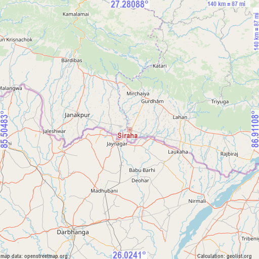
Siraha GPS coordinates[2]
26° 39' 15.192" North, 86° 12' 28.62" East
| Map corner | latitude | longitude |
|---|---|---|
| Upper-left | 27.28088°, | 85.50483° |
| Center: | 26.65422°, | 86.20795° |
| Lower-right: | 26.0241°, | 86.91108° |
| Map W x H: | 139.7×139.7 km | = 86.8×86.8mi |
| max Lat: | 30.04651° ⇑93.2% North |
| Siraha: | 26.65422° |
| min Lat: | ⇓6.8% South 26.45505° |
| min Long | Siraha | max Long |
| 80.17715° | 86.20795° | 88.09436° |
| W 81.1%⇐ | ⇒18.9% E |
Elevation
Elevation of Siraha is 82 m = 269 ft, and this is 1093.2 m = 3587 ft below average elevation for this country.
| Max E: |
5251 m = 17228 ft | 94.6% |
| Avg. | 1175.2 m = 3856 ft | |
| Siraha | 82 m = 269 ft | |
Min E: |
72 m = 236 ft | 5.4% |
See also: Nepal elevation on elevation.city.
Geographical zone
Siraha is located in North temperate zone (between Tropic of Cancer and the Arctic Circle). Distance of this Northern Tropic circle is 357.8 km =222.3 mi to South.| Distance of | km | miles | from Siraha |
|---|---|---|---|
| North Pole | 7043.4 | 4376.6 | to North |
| Arctic Circle | 4437.5 | 2757.3 | to North |
| Tropic Cancer | 357.8 | 222.3 | to South |
| Equator | 2963.7 | 1841.6 | to South |


Nearby cities:
15 places around Siraha: (largest is in red/bold)
• Bhojpur
101.1 km =62.8 mi,  55°
55°
• Biratnagar
107.9 km =67 mi,  101°
101°
• Chhetrapa1
114 km =70.8 mi,  355°
355°
• Dhankutā
117.5 km =73 mi,  71°
71°
• Dharān
107.9 km =67 mi,  80°
80°
• Gaur
93.1 km =57.8 mi,  277°
277°
• Inaruwa
93.6 km =58.2 mi,  93°
93°
• Jaleshwar
40.5 km =25.2 mi,  269°
269°
• Janakpur
29.2 km =18.1 mi,  286°
286°
• Lahān
28.3 km =17.6 mi, 74°
• Malaṅgawā
68.2 km =42.4 mi, 289°
• Rājbirāj
55.2 km =34.3 mi, 103°
• Rāmechhāp
75.6 km =47 mi,  350°
350°
• Titahari
105.9 km =65.8 mi, 89°
• Triyuga
51.1 km =31.8 mi, 72°
Sources, notices
• [Note1] Compared only with cities in Nepal existing in our database
• [Src1] Map data: © OpenStreetMap contributors (CC-BY-SA)
• [Src2] Other city data from geonames.org with taken over terms of usage.
• [Src3] Geographical zone / Annual Mean Temperature by Robert A. Rohde @ Wikipedia
