Dharān geodata
Dharān (Eastern Region) is a populated place; located in Nepal in Asia/Kathmandu (GMT+5.75) time zone. With population of 108,600 people, there are 5 cities with bigger population in this country. Compared to other cities in Nepal, 85.1% of cities are located further ↑North; 95.9% of cities are located further ←West and 67.6% of cities have higher elevation than Dharān. Note1


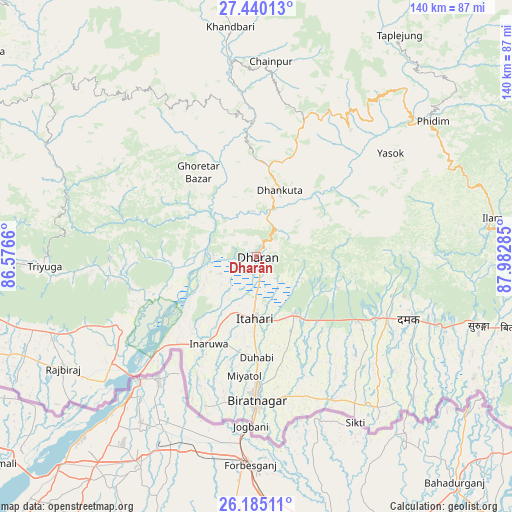
Dharān GPS coordinates[2]
26° 48' 51.696" North, 87° 16' 46.992" East
| Map corner | latitude | longitude |
|---|---|---|
| Upper-left | 27.44013°, | 86.5766° |
| Center: | 26.81436°, | 87.27972° |
| Lower-right: | 26.18511°, | 87.98285° |
| Map W x H: | 139.5×139.5 km | = 86.7×86.7mi |
| max Lat: | 30.04651° ⇑85.1% North |
| Dharān: | 26.81436° |
| min Lat: | ⇓14.9% South 26.45505° |
| min Long | Dharān | max Long |
| 80.17715° | 87.27972° | 88.09436° |
| W 95.9%⇐ | ⇒4.1% E |
Elevation
Elevation of Dharān is 375 m = 1230 ft, and this is 800.2 m = 2625 ft below average elevation for this country.
| Max E: |
5251 m = 17228 ft | 67.6% |
| Avg. | 1175.2 m = 3856 ft | |
| Dharān | 375 m = 1230 ft | |
Min E: |
72 m = 236 ft | 32.4% |
See also: Dharān elevation on elevation.city.
Geographical zone
Dharān is located in North temperate zone (between Tropic of Cancer and the Arctic Circle). Distance of this Northern Tropic circle is 375.6 km =233.4 mi to South.| Distance of | km | miles | from Dharān |
|---|---|---|---|
| North Pole | 7025.6 | 4365.5 | to North |
| Arctic Circle | 4419.7 | 2746.3 | to North |
| Tropic Cancer | 375.6 | 233.4 | to South |
| Equator | 2981.5 | 1852.6 | to South |


Nearby cities:
15 places around Dharān: (largest is in red/bold)
• Bhadrapur
86.3 km =53.6 mi,  110°
110°
• Bhojpur
46 km =28.6 mi,  329°
329°
• Biratnagar
40 km =24.9 mi,  181°
181°
• Dhankutā
19.5 km =12.1 mi,  15°
15°
• Ilām
65.2 km =40.5 mi,  80°
80°
• Inaruwa
26.5 km =16.5 mi,  209°
209°
• Khanbari
62.9 km =39.1 mi,  353°
353°
• Lahān
79.8 km =49.6 mi,  262°
262°
• Lobujya
134.3 km =83.5 mi,  340°
340°
• Namche Bazar
123.7 km =76.9 mi, 332°
• Rājbirāj
61 km =37.9 mi,  239°
239°
• Rāmechhāp
131 km =81.4 mi,  295°
295°
• Siraha
107.9 km =67 mi, 260°
• Titahari
16.8 km =10.4 mi, 181°
• Triyuga
57.7 km =35.9 mi,  267°
267°
Sources, notices
• [Note1] Compared only with cities in Nepal existing in our database
• [Src1] Map data: © OpenStreetMap contributors (CC-BY-SA)
• [Src2] Other city data from geonames.org with taken over terms of usage.
• [Src3] Geographical zone / Annual Mean Temperature by Robert A. Rohde @ Wikipedia
