Malaṅgawā geodata
Malaṅgawā (Central Region) is a populated place; located in Nepal in Asia/Kathmandu (GMT+5.75) time zone. With population of 20,284 people, there are 37 cities with bigger population in this country. Compared to other cities in Nepal, 83.8% of cities are located further ↑North; 73% of cities are located further ←West and 90.5% of cities have higher elevation than Malaṅgawā. Note1


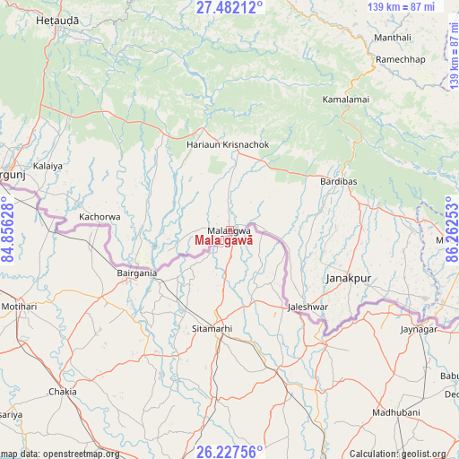
Malaṅgawā GPS coordinates[2]
26° 51' 23.688" North, 85° 33' 33.84" East
| Map corner | latitude | longitude |
|---|---|---|
| Upper-left | 27.48212°, | 84.85628° |
| Center: | 26.85658°, | 85.5594° |
| Lower-right: | 26.22756°, | 86.26253° |
| Map W x H: | 139.5×139.5 km | = 86.7×86.7mi |
| max Lat: | 30.04651° ⇑83.8% North |
| Malaṅgawā: | 26.85658° |
| min Lat: | ⇓16.2% South 26.45505° |
| min Long | Malaṅgawā | max Long |
| 80.17715° | 85.5594° | 88.09436° |
| W 73%⇐ | ⇒27% E |
Elevation
Elevation of Malaṅgawā is 89 m = 292 ft, and this is 1086.2 m = 3564 ft below average elevation for this country.
| Max E: |
5251 m = 17228 ft | 90.5% |
| Avg. | 1175.2 m = 3856 ft | |
| Malaṅgawā | 89 m = 292 ft | |
Min E: |
72 m = 236 ft | 9.5% |
See also: Nepal elevation on elevation.city.
Geographical zone
Malaṅgawā is located in North temperate zone (between Tropic of Cancer and the Arctic Circle). Distance of this Northern Tropic circle is 380.3 km =236.3 mi to South.| Distance of | km | miles | from Malaṅgawā |
|---|---|---|---|
| North Pole | 7020.9 | 4362.6 | to North |
| Arctic Circle | 4415 | 2743.4 | to North |
| Tropic Cancer | 380.3 | 236.3 | to South |
| Equator | 2986.2 | 1855.5 | to South |


Nearby cities:
15 places around Malaṅgawā: (largest is in red/bold)
• Banepā
86.3 km =53.6 mi,  357°
357°
• Bhaktapur
91.7 km =57 mi,  351°
351°
• Birgañj
69.6 km =43.2 mi,  284°
284°
• Dhulikhel
85.1 km =52.9 mi, 358°
• Gaur
29.7 km =18.5 mi,  249°
249°
• Hari Bdr Tamang House
86.4 km =53.7 mi, 353°
• Hetauda
82.2 km =51.1 mi,  320°
320°
• Jaleshwar
33.2 km =20.6 mi,  133°
133°
• Janakpur
39.1 km =24.3 mi,  111°
111°
• Lahān
92.9 km =57.7 mi,  99°
99°
• Panauti
81 km =50.3 mi, 357°
• Panauti̇̄
81.1 km =50.4 mi, 356°
• Rāmechhāp
73.9 km =45.9 mi,  45°
45°
• Siraha
68.2 km =42.4 mi, 109°
• kankrabari Dovan
86.4 km =53.7 mi, 353°
Sources, notices
• [Note1] Compared only with cities in Nepal existing in our database
• [Src1] Map data: © OpenStreetMap contributors (CC-BY-SA)
• [Src2] Other city data from geonames.org with taken over terms of usage.
• [Src3] Geographical zone / Annual Mean Temperature by Robert A. Rohde @ Wikipedia
