Inaruwa geodata
Inaruwa (Eastern Region) is a populated locality; located in Nepal in Asia/Kathmandu (GMT+5.75) time zone. With population of 70,093 people, there are 14 cities with bigger population in this country. Compared to other cities in Nepal, 95.9% of cities are located further ↑North; 90.5% of cities are located further ←West and 91.9% of cities have higher elevation than Inaruwa. Note1
Administrative division(s):
- Level 1: Eastern Region
- Level 2: Kosī Zone
- Level 3: Sunsarī
- Level 4: InaruwaN.P.


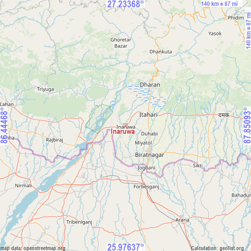
Inaruwa GPS coordinates[2]
26° 36' 24.3" North, 87° 8' 52.08" East
| Map corner | latitude | longitude |
|---|---|---|
| Upper-left | 27.23368°, | 86.44468° |
| Center: | 26.60675°, | 87.1478° |
| Lower-right: | 25.97637°, | 87.85093° |
| Map W x H: | 139.8×139.8 km | = 86.9×86.9mi |
| max Lat: | 30.04651° ⇑95.9% North |
| Inaruwa: | 26.60675° |
| min Lat: | ⇓4.1% South 26.45505° |
| min Long | Inaruwa | max Long |
| 80.17715° | 87.1478° | 88.09436° |
| W 90.5%⇐ | ⇒9.5% E |
Elevation
Elevation of Inaruwa is 87 m = 285 ft, and this is 1088.2 m = 3570 ft below average elevation for this country.
| Max E: |
5251 m = 17228 ft | 91.9% |
| Avg. | 1175.2 m = 3856 ft | |
| Inaruwa | 87 m = 285 ft | |
Min E: |
72 m = 236 ft | 8.1% |
See also: Inaruwa elevation on elevation.city.
Geographical zone
Inaruwa is located in North temperate zone (between Tropic of Cancer and the Arctic Circle). Distance of this Northern Tropic circle is 352.5 km =219 mi to South.| Distance of | km | miles | from Inaruwa |
|---|---|---|---|
| North Pole | 7048.7 | 4379.9 | to North |
| Arctic Circle | 4442.8 | 2760.6 | to North |
| Tropic Cancer | 352.5 | 219 | to South |
| Equator | 2958.4 | 1838.3 | to South |


Nearby cities:
15 places around Inaruwa: (largest is in red/bold)
• Bhadrapur
94.4 km =58.7 mi,  94°
94°
• Bhojpur
63.6 km =39.5 mi,  350°
350°
• Biratnagar
20.8 km =12.9 mi,  144°
144°
• Dhankutā
45.7 km =28.4 mi,  23°
23°
• Dharān
26.5 km =16.5 mi,  29°
29°
• Ilām
84.5 km =52.5 mi,  66°
66°
• Jaleshwar
134 km =83.3 mi,  272°
272°
• Janakpur
122.1 km =75.9 mi,  276°
276°
• Khanbari
85.7 km =53.3 mi,  3°
3°
• Lahān
67.3 km =41.8 mi, 280°
• Rājbirāj
40.5 km =25.2 mi,  259°
259°
• Rāmechhāp
132 km =82 mi,  307°
307°
• Siraha
93.6 km =58.2 mi, 273°
• Titahari
14.1 km =8.8 mi,  63°
63°
• Triyuga
49.1 km =30.5 mi,  294°
294°
Sources, notices
• [Note1] Compared only with cities in Nepal existing in our database
• [Src1] Map data: © OpenStreetMap contributors (CC-BY-SA)
• [Src2] Other city data from geonames.org with taken over terms of usage.
• [Src3] Geographical zone / Annual Mean Temperature by Robert A. Rohde @ Wikipedia
