Bhojpur geodata
Bhojpur (Eastern Region) is a seat of a third-order administrative division; located in Nepal in Asia/Kathmandu (GMT+5.75) time zone. With population of 3,250 people, there are 51 cities with bigger population in this country. Compared to other cities in Nepal, 78.4% of cities are located further ↑North; 89.2% of cities are located further ←West and 77% of cities have lower elevation than Bhojpur. Note1


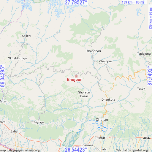
Bhojpur GPS coordinates[2]
27° 10' 17.4" North, 87° 2' 45.852" East
| Map corner | latitude | longitude |
|---|---|---|
| Upper-left | 27.79527°, | 86.34295° |
| Center: | 27.1715°, | 87.04607° |
| Lower-right: | 26.54423°, | 87.7492° |
| Map W x H: | 139.1×139.1 km | = 86.4×86.4mi |
| max Lat: | 30.04651° ⇑78.4% North |
| Bhojpur: | 27.1715° |
| min Lat: | ⇓21.6% South 26.45505° |
| min Long | Bhojpur | max Long |
| 80.17715° | 87.04607° | 88.09436° |
| W 89.2%⇐ | ⇒10.8% E |
Elevation
Elevation of Bhojpur is 1573 m = 5161 ft, and this is 397.8 m = 1305 ft above average elevation for this country.
| Max E: |
5251 m = 17228 ft | 23% |
| Bhojpur | 1573 m 5161 ft | |
| Avg. | 1175.2 m = 3856 ft | |
Min E: |
72 m = 236 ft | 77% |
See also: Nepal elevation on elevation.city.
Geographical zone
Bhojpur is located in North temperate zone (between Tropic of Cancer and the Arctic Circle). Distance of this Northern Tropic circle is 415.3 km =258.1 mi to South.| Distance of | km | miles | from Bhojpur |
|---|---|---|---|
| North Pole | 6985.9 | 4340.8 | to North |
| Arctic Circle | 4380 | 2721.6 | to North |
| Tropic Cancer | 415.3 | 258.1 | to South |
| Equator | 3021.2 | 1877.3 | to South |


Nearby cities:
15 places around Bhojpur: (largest is in red/bold)
• Biratnagar
82.7 km =51.4 mi,  164°
164°
• Chhetrapa1
107.5 km =66.8 mi,  301°
301°
• Dhankutā
35.3 km =21.9 mi,  126°
126°
• Dharān
46 km =28.6 mi,  149°
149°
• Ilām
92.1 km =57.2 mi,  108°
108°
• Inaruwa
63.6 km =39.5 mi,  170°
170°
• Khanbari
27.8 km =17.3 mi,  35°
35°
• Lahān
75.1 km =46.7 mi,  228°
228°
• Lobujya
89.5 km =55.6 mi,  345°
345°
• Namche Bazar
77.9 km =48.4 mi,  334°
334°
• Rājbirāj
76.2 km =47.3 mi,  202°
202°
• Rāmechhāp
96.3 km =59.8 mi,  280°
280°
• Siraha
101.1 km =62.8 mi,  235°
235°
• Titahari
60.8 km =37.8 mi, 158°
• Triyuga
54.4 km =33.8 mi,  219°
219°
Sources, notices
• [Note1] Compared only with cities in Nepal existing in our database
• [Src1] Map data: © OpenStreetMap contributors (CC-BY-SA)
• [Src2] Other city data from geonames.org with taken over terms of usage.
• [Src3] Geographical zone / Annual Mean Temperature by Robert A. Rohde @ Wikipedia
