La Trinidad geodata
La Trinidad (Herrera) is a seat of a third-order administrative division; located in Panama in America/Panama (GMT-5) time zone. With population of 123 people, there are 643 cities with bigger population in this country. Compared to other cities in Panama, 86% of cities are located further ↑North; 54.5% of cities are located further →East and 55.5% of cities have lower elevation than La Trinidad. Note1


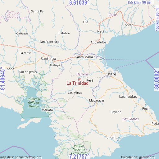
La Trinidad GPS coordinates[2]
7° 54' 52.452" North, 80° 42' 11.952" West
| Map corner | latitude | longitude |
|---|---|---|
| Upper-left | 8.61039°, | -81.40645° |
| Center: | 7.91457°, | -80.70332° |
| Lower-right: | 7.21757°, | -80.0002° |
| Map W x H: | 154.9×154.9 km | = 96.3×96.3mi |
| max Lat: | 9.60898° ⇑86% North |
| La Trinidad: | 7.91457° |
| min Lat: | ⇓14% South 7.26534° |
| min Long | La Trinidad | max Long |
| -82.91275° | -80.70332° | -77.38965° |
| W 45.5%⇐ | ⇒54.5% E |
Elevation
Elevation of La Trinidad is 90 m = 295 ft, and this is 82.1 m = 269 ft below average elevation for this country.
| Max E: |
2103 m = 6900 ft | 44.5% |
| Avg. | 172.1 m = 565 ft | |
| La Trinidad | 90 m = 295 ft | |
Min E: |
-1 m = -3 ft | 55.5% |
See also: Panama elevation on elevation.city.
Geographical zone
La Trinidad is located in North Torrid zone (between Equator and Tropic of Cancer). Distance of Equator is 880 km =546.8 mi to South.| Distance of | km | miles | from La Trinidad |
|---|---|---|---|
| North Pole | 9127 | 5671.3 | to North |
| Arctic Circle | 6521.2 | 4052.1 | to North |
| Tropic Cancer | 1725.9 | 1072.4 | to North |
| Equator | 880 | 546.8 | to South |


Nearby cities:
15 places around La Trinidad: (largest is in red/bold)
• Cabuya
10.1 km =6.3 mi,  318°
318°
• Cabuya
15.2 km =9.4 mi,  31°
31°
• Chumical
8.2 km =5.1 mi,  198°
198°
• El Pedregoso
7.6 km =4.7 mi,  71°
71°
• El Pájaro
15 km =9.3 mi,  77°
77°
• Las Guabas
11.4 km =7.1 mi,  267°
267°
• Las Minas
14 km =8.7 mi, 199°
• Llano Grande
6.7 km =4.2 mi,  352°
352°
• Llano de La Cruz
7.9 km =4.9 mi,  58°
58°
• Los Castillos
12.2 km =7.6 mi,  49°
49°
• Ocú
8.9 km =5.5 mi,  289°
289°
• Pesé
9.8 km =6.1 mi,  93°
93°
• Peñas Chatas
15.7 km =9.8 mi, 315°
• Rincón Hondo
13.4 km =8.3 mi,  125°
125°
• Sabana Grande
8.1 km =5 mi,  118°
118°
Sources, notices
• [Note1] Compared only with cities in Panama existing in our database
• [Src1] Map data: © OpenStreetMap contributors (CC-BY-SA)
• [Src2] Other city data from geonames.org with taken over terms of usage.
• [Src3] Geographical zone / Annual Mean Temperature by Robert A. Rohde @ Wikipedia
