Llano Grande geodata
Llano Grande (Herrera) is a seat of a third-order administrative division; located in Panama in America/Panama (GMT-5) time zone. With population of 203 people, there are 601 cities with bigger population in this country. Compared to other cities in Panama, 82.7% of cities are located further ↑North; 54.9% of cities are located further →East and 50.5% of cities have lower elevation than Llano Grande. Note1


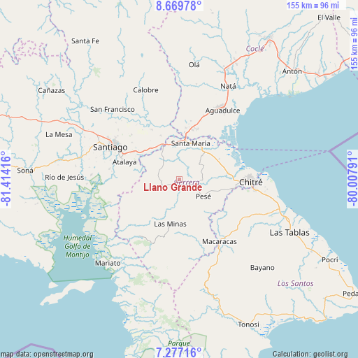
Llano Grande GPS coordinates[2]
7° 58' 26.616" North, 80° 42' 39.708" West
| Map corner | latitude | longitude |
|---|---|---|
| Upper-left | 8.66978°, | -81.41416° |
| Center: | 7.97406°, | -80.71103° |
| Lower-right: | 7.27716°, | -80.00791° |
| Map W x H: | 154.8×154.8 km | = 96.2×96.2mi |
| max Lat: | 9.60898° ⇑82.7% North |
| Llano Grande: | 7.97406° |
| min Lat: | ⇓17.3% South 7.26534° |
| min Long | Llano Grande | max Long |
| -82.91275° | -80.71103° | -77.38965° |
| W 45.1%⇐ | ⇒54.9% E |
Elevation
Elevation of Llano Grande is 74 m = 243 ft, and this is 98.1 m = 322 ft below average elevation for this country.
| Max E: |
2103 m = 6900 ft | 49.5% |
| Avg. | 172.1 m = 565 ft | |
| Llano Grande | 74 m = 243 ft | |
Min E: |
-1 m = -3 ft | 50.5% |
See also: Panama elevation on elevation.city.
Geographical zone
Llano Grande is located in North Torrid zone (between Equator and Tropic of Cancer). Distance of Equator is 886.6 km =550.9 mi to South.| Distance of | km | miles | from Llano Grande |
|---|---|---|---|
| North Pole | 9120.4 | 5667.2 | to North |
| Arctic Circle | 6514.5 | 4047.9 | to North |
| Tropic Cancer | 1719.3 | 1068.3 | to North |
| Equator | 886.6 | 550.9 | to South |


Nearby cities:
15 places around Llano Grande: (largest is in red/bold)
• Cabuya
5.9 km =3.7 mi,  279°
279°
• Cabuya
10.8 km =6.7 mi,  53°
53°
• Chupampa
13.5 km =8.4 mi,  327°
327°
• El Limón
11.6 km =7.2 mi,  323°
323°
• El Pedregoso
9.1 km =5.7 mi,  117°
117°
• La Trinidad
6.7 km =4.2 mi,  172°
172°
• Las Guabas
12.8 km =8 mi,  235°
235°
• Llano de La Cruz
8 km =5 mi,  108°
108°
• Los Castillos
10.2 km =6.3 mi,  82°
82°
• Ocú
8.4 km =5.2 mi, 243°
• Pesé
12.9 km =8 mi, 124°
• Peñas Chatas
11.2 km =7 mi,  294°
294°
• Portobelillo
13.6 km =8.5 mi,  69°
69°
• Potuga
13.9 km =8.6 mi,  44°
44°
• Sabana Grande
13.2 km =8.2 mi,  142°
142°
Sources, notices
• [Note1] Compared only with cities in Panama existing in our database
• [Src1] Map data: © OpenStreetMap contributors (CC-BY-SA)
• [Src2] Other city data from geonames.org with taken over terms of usage.
• [Src3] Geographical zone / Annual Mean Temperature by Robert A. Rohde @ Wikipedia
