Palmira geodata
Palmira (Chiriquí) is a populated place; located in Panama in America/Panama (GMT-5) time zone. With population of 1,144 people, there are 215 cities with bigger population in this country. Compared to other cities in Panama, 70.9% of cities are located further ↓South; 87.3% of cities are located further →East and 98% of cities have lower elevation than Palmira. Note1


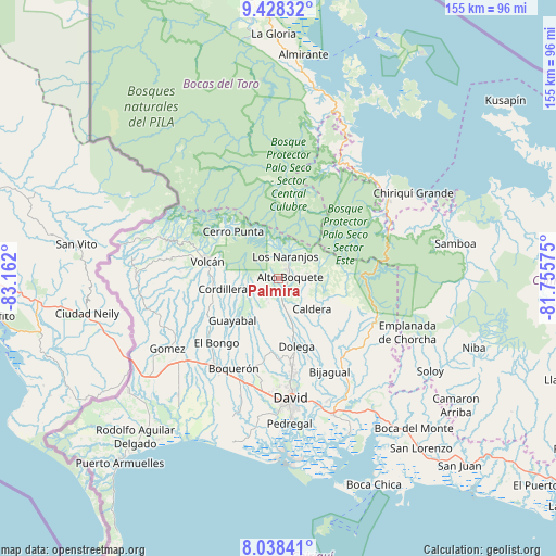
Palmira GPS coordinates[2]
8° 44' 2.436" North, 82° 27' 31.932" West
| Map corner | latitude | longitude |
|---|---|---|
| Upper-left | 9.42832°, | -83.162° |
| Center: | 8.73401°, | -82.45887° |
| Lower-right: | 8.03841°, | -81.75575° |
| Map W x H: | 154.5×154.5 km | = 96×96mi |
| max Lat: | 9.60898° ⇑29.1% North |
| Palmira: | 8.73401° |
| min Lat: | ⇓70.9% South 7.26534° |
| min Long | Palmira | max Long |
| -82.91275° | -82.45887° | -77.38965° |
| W 12.7%⇐ | ⇒87.3% E |
Elevation
Elevation of Palmira is 1084 m = 3556 ft, and this is 911.9 m = 2992 ft above average elevation for this country.
| Max E: |
2103 m = 6900 ft | 2% |
| Palmira | 1084 m 3556 ft | |
| Avg. | 172.1 m = 565 ft | |
Min E: |
-1 m = -3 ft | 98% |
See also: Panama elevation on elevation.city.
Geographical zone
Palmira is located in North Torrid zone (between Equator and Tropic of Cancer). Distance of Equator is 971.1 km =603.4 mi to South.| Distance of | km | miles | from Palmira |
|---|---|---|---|
| North Pole | 9035.9 | 5614.6 | to North |
| Arctic Circle | 6430 | 3995.4 | to North |
| Tropic Cancer | 1634.8 | 1015.8 | to North |
| Equator | 971.1 | 603.4 | to South |


Nearby cities:
15 places around Palmira: (largest is in red/bold)
• Alto Boquete
2.9 km =1.8 mi,  88°
88°
• Alto Lino
7.7 km =4.8 mi,  19°
19°
• Alto Quiel
8.1 km =5 mi,  347°
347°
• Bajo Boquete
5 km =3.1 mi,  34°
34°
• Boquete
5.5 km =3.4 mi, 20°
• Caldera
12.8 km =8 mi,  137°
137°
• Cordillera
16.2 km =10.1 mi,  259°
259°
• El Banco
7.6 km =4.7 mi,  231°
231°
• Jaramillo Arriba
8 km =5 mi, 28°
• Los Naranjos
6.6 km =4.1 mi,  11°
11°
• Mague
12.8 km =8 mi,  125°
125°
• Palmira Centro
1 km =0.6 mi,  49°
49°
• Potrerillos Abajo
10.9 km =6.8 mi,  195°
195°
• Potrerillos Arriba
6.4 km =4 mi,  213°
213°
• Rovira Arriba
11.6 km =7.2 mi, 202°
Sources, notices
• [Note1] Compared only with cities in Panama existing in our database
• [Src1] Map data: © OpenStreetMap contributors (CC-BY-SA)
• [Src2] Other city data from geonames.org with taken over terms of usage.
• [Src3] Geographical zone / Annual Mean Temperature by Robert A. Rohde @ Wikipedia
