Palmira Centro geodata
Palmira Centro (Chiriquí) is a seat of a third-order administrative division; located in Panama in America/Panama (GMT-5) time zone. With population of 920 people, there are 277 cities with bigger population in this country. Compared to other cities in Panama, 71.3% of cities are located further ↓South; 87% of cities are located further →East and 98.1% of cities have lower elevation than Palmira Centro. Note1


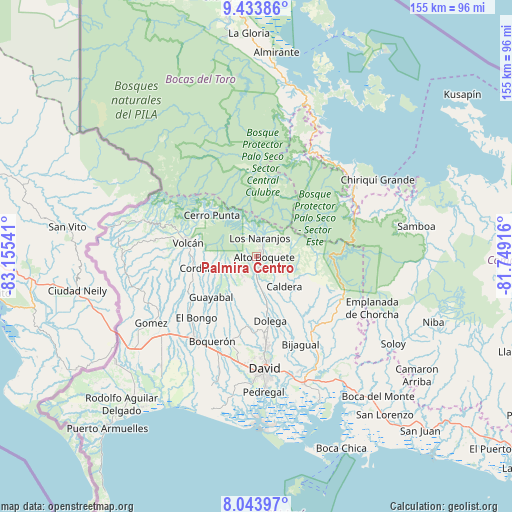
Palmira Centro GPS coordinates[2]
8° 44' 22.416" North, 82° 27' 8.208" West
| Map corner | latitude | longitude |
|---|---|---|
| Upper-left | 9.43386°, | -83.15541° |
| Center: | 8.73956°, | -82.45228° |
| Lower-right: | 8.04397°, | -81.74916° |
| Map W x H: | 154.5×154.5 km | = 96×96mi |
| max Lat: | 9.60898° ⇑28.7% North |
| Palmira Centro: | 8.73956° |
| min Lat: | ⇓71.3% South 7.26534° |
| min Long | Palmira Centro | max Long |
| -82.91275° | -82.45228° | -77.38965° |
| W 13%⇐ | ⇒87% E |
Elevation
Elevation of Palmira Centro is 1095 m = 3593 ft, and this is 922.9 m = 3028 ft above average elevation for this country.
| Max E: |
2103 m = 6900 ft | 1.9% |
| Palmira Centro | 1095 m 3593 ft | |
| Avg. | 172.1 m = 565 ft | |
Min E: |
-1 m = -3 ft | 98.1% |
See also: Panama elevation on elevation.city.
Geographical zone
Palmira Centro is located in North Torrid zone (between Equator and Tropic of Cancer). Distance of Equator is 971.7 km =603.8 mi to South.| Distance of | km | miles | from Palmira Centro |
|---|---|---|---|
| North Pole | 9035.3 | 5614.3 | to North |
| Arctic Circle | 6429.4 | 3995 | to North |
| Tropic Cancer | 1634.2 | 1015.4 | to North |
| Equator | 971.7 | 603.8 | to South |


Nearby cities:
15 places around Palmira Centro: (largest is in red/bold)
• Alto Boquete
2.3 km =1.4 mi,  104°
104°
• Alto Lino
6.9 km =4.3 mi,  16°
16°
• Alto Quiel
7.7 km =4.8 mi,  341°
341°
• Bajo Boquete
4 km =2.5 mi,  31°
31°
• Boquete
4.7 km =2.9 mi,  14°
14°
• Caldera
12.8 km =8 mi,  141°
141°
• El Banco
8.5 km =5.3 mi,  231°
231°
• Jaramillo Arriba
7.2 km =4.5 mi, 25°
• Los Naranjos
5.9 km =3.7 mi, 6°
• Mague
12.6 km =7.8 mi,  129°
129°
• Paja de Sombrero
15.9 km =9.9 mi,  113°
113°
• Palmira
1 km =0.6 mi, 229°
• Potrerillos Abajo
11.7 km =7.3 mi,  198°
198°
• Potrerillos Arriba
7.4 km =4.6 mi,  215°
215°
• Rovira Arriba
12.4 km =7.7 mi, 204°
Sources, notices
• [Note1] Compared only with cities in Panama existing in our database
• [Src1] Map data: © OpenStreetMap contributors (CC-BY-SA)
• [Src2] Other city data from geonames.org with taken over terms of usage.
• [Src3] Geographical zone / Annual Mean Temperature by Robert A. Rohde @ Wikipedia
