Alto Lino geodata
Alto Lino (Chiriquí) is a populated place; located in Panama in America/Panama (GMT-5) time zone. With population of 706 people, there are 352 cities with bigger population in this country. Compared to other cities in Panama, 73.8% of cities are located further ↓South; 86.1% of cities are located further →East and 99.1% of cities have lower elevation than Alto Lino. Note1


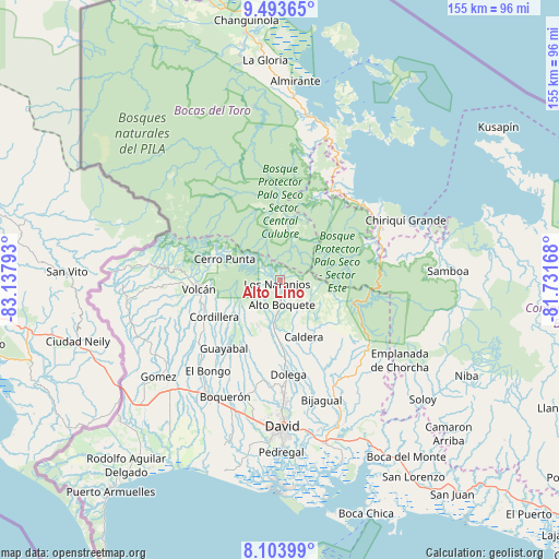
Alto Lino GPS coordinates[2]
8° 47' 58.092" North, 82° 26' 5.28" West
| Map corner | latitude | longitude |
|---|---|---|
| Upper-left | 9.49365°, | -83.13793° |
| Center: | 8.79947°, | -82.4348° |
| Lower-right: | 8.10399°, | -81.73168° |
| Map W x H: | 154.5×154.5 km | = 96×96mi |
| max Lat: | 9.60898° ⇑26.2% North |
| Alto Lino: | 8.79947° |
| min Lat: | ⇓73.8% South 7.26534° |
| min Long | Alto Lino | max Long |
| -82.91275° | -82.4348° | -77.38965° |
| W 13.9%⇐ | ⇒86.1% E |
Elevation
Elevation of Alto Lino is 1255 m = 4117 ft, and this is 1082.9 m = 3553 ft above average elevation for this country.
| Max E: |
2103 m = 6900 ft | 0.90000000000001% |
| Alto Lino | 1255 m 4117 ft | |
| Avg. | 172.1 m = 565 ft | |
Min E: |
-1 m = -3 ft | 99.1% |
See also: Panama elevation on elevation.city.
Geographical zone
Alto Lino is located in North Torrid zone (between Equator and Tropic of Cancer). Distance of Equator is 978.4 km =607.9 mi to South.| Distance of | km | miles | from Alto Lino |
|---|---|---|---|
| North Pole | 9028.7 | 5610.2 | to North |
| Arctic Circle | 6422.8 | 3990.9 | to North |
| Tropic Cancer | 1627.5 | 1011.3 | to North |
| Equator | 978.4 | 607.9 | to South |


Nearby cities:
15 places around Alto Lino: (largest is in red/bold)
• Alto Boquete
7.2 km =4.5 mi,  177°
177°
• Alto Quiel
4.4 km =2.7 mi,  278°
278°
• Bajo Boquete
3.2 km =2 mi, 176°
• Barrio Guadalupe
16.1 km =10 mi,  296°
296°
• Boquete
2.3 km =1.4 mi,  198°
198°
• Caldera
17.8 km =11.1 mi,  160°
160°
• Cerro Punta
16.1 km =10 mi,  290°
290°
• El Banco
14.7 km =9.1 mi,  215°
215°
• Jaramillo Arriba
1.2 km =0.7 mi,  99°
99°
• Los Naranjos
1.5 km =0.9 mi,  237°
237°
• Mague
16.6 km =10.3 mi,  151°
151°
• Paja de Sombrero
18.1 km =11.2 mi,  135°
135°
• Palmira
7.7 km =4.8 mi, 199°
• Palmira Centro
6.9 km =4.3 mi, 196°
• Potrerillos Arriba
14.1 km =8.8 mi,  205°
205°
Sources, notices
• [Note1] Compared only with cities in Panama existing in our database
• [Src1] Map data: © OpenStreetMap contributors (CC-BY-SA)
• [Src2] Other city data from geonames.org with taken over terms of usage.
• [Src3] Geographical zone / Annual Mean Temperature by Robert A. Rohde @ Wikipedia
