Mague geodata
Mague (Chiriquí) is a populated place; located in Panama in America/Panama (GMT-5) time zone. With population of 501 people, there are 488 cities with bigger population in this country. Compared to other cities in Panama, 68.8% of cities are located further ↓South; 83.2% of cities are located further →East and 87.9% of cities have lower elevation than Mague. Note1


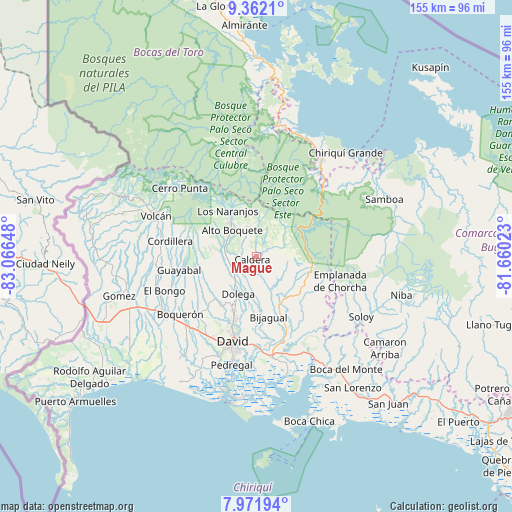
Mague GPS coordinates[2]
8° 40' 3.576" North, 82° 21' 48.06" West
| Map corner | latitude | longitude |
|---|---|---|
| Upper-left | 9.3621°, | -83.06648° |
| Center: | 8.66766°, | -82.36335° |
| Lower-right: | 7.97194°, | -81.66023° |
| Map W x H: | 154.6×154.6 km | = 96.1×96.1mi |
| max Lat: | 9.60898° ⇑31.2% North |
| Mague: | 8.66766° |
| min Lat: | ⇓68.8% South 7.26534° |
| min Long | Mague | max Long |
| -82.91275° | -82.36335° | -77.38965° |
| W 16.8%⇐ | ⇒83.2% E |
Elevation
Elevation of Mague is 393 m = 1289 ft, and this is 220.9 m = 725 ft above average elevation for this country.
| Max E: |
2103 m = 6900 ft | 12.1% |
| Mague | 393 m 1289 ft | |
| Avg. | 172.1 m = 565 ft | |
Min E: |
-1 m = -3 ft | 87.9% |
See also: Panama elevation on elevation.city.
Geographical zone
Mague is located in North Torrid zone (between Equator and Tropic of Cancer). Distance of Equator is 963.8 km =598.9 mi to South.| Distance of | km | miles | from Mague |
|---|---|---|---|
| North Pole | 9043.3 | 5619.2 | to North |
| Arctic Circle | 6437.4 | 4000 | to North |
| Tropic Cancer | 1642.2 | 1020.4 | to North |
| Equator | 963.8 | 598.9 | to South |


Nearby cities:
15 places around Mague: (largest is in red/bold)
• Alto Boquete
10.6 km =6.6 mi,  314°
314°
• Angostura de Cochea Arriba
14.7 km =9.1 mi,  185°
185°
• Bajo Boquete
13.8 km =8.6 mi,  326°
326°
• Boquete
15.2 km =9.4 mi, 325°
• Caldera
2.8 km =1.7 mi,  222°
222°
• Dolega District
12.5 km =7.8 mi,  206°
206°
• Dos Ríos Arriba
13.5 km =8.4 mi,  197°
197°
• El Flor
13.9 km =8.6 mi, 216°
• Paja de Sombrero
5.2 km =3.2 mi,  70°
70°
• Palmira
12.8 km =8 mi, 305°
• Palmira Centro
12.6 km =7.8 mi, 309°
• Potrerillos Abajo
13.8 km =8.6 mi,  257°
257°
• Potrerillos Arriba
14.2 km =8.8 mi,  278°
278°
• Pueblo Nuevo
11.4 km =7.1 mi, 215°
• Valle de La Mina
14.4 km =8.9 mi,  91°
91°
Sources, notices
• [Note1] Compared only with cities in Panama existing in our database
• [Src1] Map data: © OpenStreetMap contributors (CC-BY-SA)
• [Src2] Other city data from geonames.org with taken over terms of usage.
• [Src3] Geographical zone / Annual Mean Temperature by Robert A. Rohde @ Wikipedia
