Boquete geodata
Boquete (Chiriquí) is a populated place; located in Panama in America/Panama (GMT-5) time zone. With population of 6,123 people, there are 59 cities with bigger population in this country. Compared to other cities in Panama, 72.7% of cities are located further ↓South; 86.6% of cities are located further →East and 98.6% of cities have lower elevation than Boquete. Note1


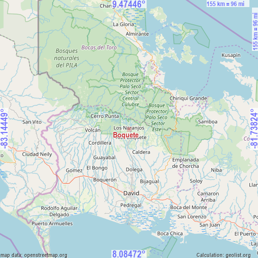
Boquete GPS coordinates[2]
8° 46' 48.864" North, 82° 26' 28.896" West
| Map corner | latitude | longitude |
|---|---|---|
| Upper-left | 9.47446°, | -83.14449° |
| Center: | 8.78024°, | -82.44136° |
| Lower-right: | 8.08472°, | -81.73824° |
| Map W x H: | 154.5×154.5 km | = 96×96mi |
| max Lat: | 9.60898° ⇑27.3% North |
| Boquete: | 8.78024° |
| min Lat: | ⇓72.7% South 7.26534° |
| min Long | Boquete | max Long |
| -82.91275° | -82.44136° | -77.38965° |
| W 13.4%⇐ | ⇒86.6% E |
Elevation
Elevation of Boquete is 1131 m = 3711 ft, and this is 958.9 m = 3146 ft above average elevation for this country.
| Max E: |
2103 m = 6900 ft | 1.4% |
| Boquete | 1131 m 3711 ft | |
| Avg. | 172.1 m = 565 ft | |
Min E: |
-1 m = -3 ft | 98.6% |
See also: Panama elevation on elevation.city.
Geographical zone
Boquete is located in North Torrid zone (between Equator and Tropic of Cancer). Distance of Equator is 976.3 km =606.6 mi to South.| Distance of | km | miles | from Boquete |
|---|---|---|---|
| North Pole | 9030.8 | 5611.5 | to North |
| Arctic Circle | 6424.9 | 3992.2 | to North |
| Tropic Cancer | 1629.6 | 1012.6 | to North |
| Equator | 976.3 | 606.6 | to South |


Nearby cities:
15 places around Boquete: (largest is in red/bold)
• Alto Boquete
5.2 km =3.2 mi,  168°
168°
• Alto Lino
2.3 km =1.4 mi,  18°
18°
• Alto Quiel
4.6 km =2.9 mi,  307°
307°
• Bajo Boquete
1.4 km =0.9 mi,  139°
139°
• Barrio Guadalupe
16.5 km =10.3 mi,  304°
304°
• Caldera
16 km =9.9 mi,  155°
155°
• Cerro Punta
16.4 km =10.2 mi, 298°
• El Banco
12.6 km =7.8 mi,  218°
218°
• Jaramillo Arriba
2.7 km =1.7 mi,  43°
43°
• Los Naranjos
1.4 km =0.9 mi,  336°
336°
• Mague
15.2 km =9.4 mi,  145°
145°
• Palmira
5.5 km =3.4 mi,  200°
200°
• Palmira Centro
4.7 km =2.9 mi,  194°
194°
• Potrerillos Abajo
16.4 km =10.2 mi, 197°
• Potrerillos Arriba
11.9 km =7.4 mi,  207°
207°
Sources, notices
• [Note1] Compared only with cities in Panama existing in our database
• [Src1] Map data: © OpenStreetMap contributors (CC-BY-SA)
• [Src2] Other city data from geonames.org with taken over terms of usage.
• [Src3] Geographical zone / Annual Mean Temperature by Robert A. Rohde @ Wikipedia
