Alto Boquete geodata
Alto Boquete (Chiriquí) is a seat of a third-order administrative division; located in Panama in America/Panama (GMT-5) time zone. With population of 4,746 people, there are 66 cities with bigger population in this country. Compared to other cities in Panama, 71% of cities are located further ↓South; 85.9% of cities are located further →East and 97.5% of cities have lower elevation than Alto Boquete. Note1


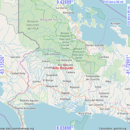
Alto Boquete GPS coordinates[2]
8° 44' 4.488" North, 82° 25' 55.668" West
| Map corner | latitude | longitude |
|---|---|---|
| Upper-left | 9.42889°, | -83.13526° |
| Center: | 8.73458°, | -82.43213° |
| Lower-right: | 8.03898°, | -81.72901° |
| Map W x H: | 154.5×154.5 km | = 96×96mi |
| max Lat: | 9.60898° ⇑29% North |
| Alto Boquete: | 8.73458° |
| min Lat: | ⇓71% South 7.26534° |
| min Long | Alto Boquete | max Long |
| -82.91275° | -82.43213° | -77.38965° |
| W 14.1%⇐ | ⇒85.9% E |
Elevation
Elevation of Alto Boquete is 1031 m = 3383 ft, and this is 858.9 m = 2818 ft above average elevation for this country.
| Max E: |
2103 m = 6900 ft | 2.5% |
| Alto Boquete | 1031 m 3383 ft | |
| Avg. | 172.1 m = 565 ft | |
Min E: |
-1 m = -3 ft | 97.5% |
See also: Panama elevation on elevation.city.
Geographical zone
Alto Boquete is located in North Torrid zone (between Equator and Tropic of Cancer). Distance of Equator is 971.2 km =603.5 mi to South.| Distance of | km | miles | from Alto Boquete |
|---|---|---|---|
| North Pole | 9035.9 | 5614.6 | to North |
| Arctic Circle | 6430 | 3995.4 | to North |
| Tropic Cancer | 1634.7 | 1015.8 | to North |
| Equator | 971.2 | 603.5 | to South |


Nearby cities:
15 places around Alto Boquete: (largest is in red/bold)
• Alto Lino
7.2 km =4.5 mi,  357°
357°
• Alto Quiel
9.1 km =5.7 mi,  329°
329°
• Bajo Boquete
4 km =2.5 mi, 358°
• Boquete
5.2 km =3.2 mi,  348°
348°
• Caldera
11.1 km =6.9 mi,  149°
149°
• El Banco
10.1 km =6.3 mi,  241°
241°
• Jaramillo Arriba
7.1 km =4.4 mi,  6°
6°
• Los Naranjos
6.6 km =4.1 mi, 345°
• Mague
10.6 km =6.6 mi,  134°
134°
• Paja de Sombrero
13.7 km =8.5 mi,  114°
114°
• Palmira
2.9 km =1.8 mi,  268°
268°
• Palmira Centro
2.3 km =1.4 mi,  284°
284°
• Potrerillos Abajo
12.1 km =7.5 mi,  209°
209°
• Potrerillos Arriba
8.5 km =5.3 mi,  229°
229°
• Rovira Arriba
13 km =8.1 mi, 214°
Sources, notices
• [Note1] Compared only with cities in Panama existing in our database
• [Src1] Map data: © OpenStreetMap contributors (CC-BY-SA)
• [Src2] Other city data from geonames.org with taken over terms of usage.
• [Src3] Geographical zone / Annual Mean Temperature by Robert A. Rohde @ Wikipedia
