Caldera geodata
Caldera (Chiriquí) is a seat of a third-order administrative division; located in Panama in America/Panama (GMT-5) time zone. With population of 355 people, there are 538 cities with bigger population in this country. Compared to other cities in Panama, 67.5% of cities are located further ↓South; 83.5% of cities are located further →East and 86.6% of cities have lower elevation than Caldera. Note1


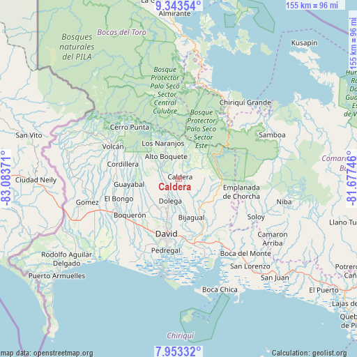
Caldera GPS coordinates[2]
8° 38' 56.652" North, 82° 22' 50.088" West
| Map corner | latitude | longitude |
|---|---|---|
| Upper-left | 9.34354°, | -83.08371° |
| Center: | 8.64907°, | -82.38058° |
| Lower-right: | 7.95332°, | -81.67746° |
| Map W x H: | 154.6×154.6 km | = 96.1×96.1mi |
| max Lat: | 9.60898° ⇑32.5% North |
| Caldera: | 8.64907° |
| min Lat: | ⇓67.5% South 7.26534° |
| min Long | Caldera | max Long |
| -82.91275° | -82.38058° | -77.38965° |
| W 16.5%⇐ | ⇒83.5% E |
Elevation
Elevation of Caldera is 370 m = 1214 ft, and this is 197.9 m = 649 ft above average elevation for this country.
| Max E: |
2103 m = 6900 ft | 13.4% |
| Caldera | 370 m 1214 ft | |
| Avg. | 172.1 m = 565 ft | |
Min E: |
-1 m = -3 ft | 86.6% |
See also: Panama elevation on elevation.city.
Geographical zone
Caldera is located in North Torrid zone (between Equator and Tropic of Cancer). Distance of Equator is 961.7 km =597.6 mi to South.| Distance of | km | miles | from Caldera |
|---|---|---|---|
| North Pole | 9045.4 | 5620.5 | to North |
| Arctic Circle | 6439.5 | 4001.3 | to North |
| Tropic Cancer | 1644.2 | 1021.7 | to North |
| Equator | 961.7 | 597.6 | to South |


Nearby cities:
15 places around Caldera: (largest is in red/bold)
• Alto Boquete
11.1 km =6.9 mi,  329°
329°
• Angostura de Cochea Arriba
12.6 km =7.8 mi,  177°
177°
• Caimito
12.7 km =7.9 mi,  199°
199°
• Dolega District
9.9 km =6.2 mi, 201°
• Dos Ríos Abajo
13.4 km =8.3 mi, 182°
• Dos Ríos Arriba
11 km =6.8 mi,  191°
191°
• El Flor
11.1 km =6.9 mi,  215°
215°
• Mague
2.8 km =1.7 mi,  42°
42°
• Paja de Sombrero
7.8 km =4.8 mi,  60°
60°
• Palmira
12.8 km =8 mi,  317°
317°
• Palmira Centro
12.8 km =8 mi, 321°
• Potrerillos Abajo
11.6 km =7.2 mi,  264°
264°
• Potrerillos Arriba
12.8 km =8 mi,  288°
288°
• Pueblo Nuevo
8.6 km =5.3 mi,  212°
212°
• Rovira Arriba
13.1 km =8.1 mi, 264°
Sources, notices
• [Note1] Compared only with cities in Panama existing in our database
• [Src1] Map data: © OpenStreetMap contributors (CC-BY-SA)
• [Src2] Other city data from geonames.org with taken over terms of usage.
• [Src3] Geographical zone / Annual Mean Temperature by Robert A. Rohde @ Wikipedia
