Paja de Sombrero geodata
Paja de Sombrero (Chiriquí) is a seat of a third-order administrative division; located in Panama in America/Panama (GMT-5) time zone. With population of 157 people, there are 628 cities with bigger population in this country. Compared to other cities in Panama, 69.4% of cities are located further ↓South; 82.5% of cities are located further →East and 88.3% of cities have lower elevation than Paja de Sombrero. Note1


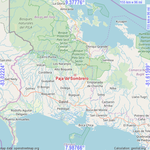
Paja de Sombrero GPS coordinates[2]
8° 41' 0.06" North, 82° 19' 8.796" West
| Map corner | latitude | longitude |
|---|---|---|
| Upper-left | 9.37776°, | -83.02224° |
| Center: | 8.68335°, | -82.31911° |
| Lower-right: | 7.98766°, | -81.61599° |
| Map W x H: | 154.6×154.6 km | = 96.1×96.1mi |
| max Lat: | 9.60898° ⇑30.6% North |
| Paja de Sombrero: | 8.68335° |
| min Lat: | ⇓69.4% South 7.26534° |
| min Long | Paja de Sombrer | max Long |
| -82.91275° | -82.31911° | -77.38965° |
| W 17.5%⇐ | ⇒82.5% E |
Elevation
Elevation of Paja de Sombrero is 402 m = 1319 ft, and this is 229.9 m = 754 ft above average elevation for this country.
| Max E: |
2103 m = 6900 ft | 11.7% |
| Paja de Sombrero | 402 m 1319 ft | |
| Avg. | 172.1 m = 565 ft | |
Min E: |
-1 m = -3 ft | 88.3% |
See also: Panama elevation on elevation.city.
Geographical zone
Paja de Sombrero is located in North Torrid zone (between Equator and Tropic of Cancer). Distance of Equator is 965.5 km =599.9 mi to South.| Distance of | km | miles | from Paja de Sombrero |
|---|---|---|---|
| North Pole | 9041.6 | 5618.2 | to North |
| Arctic Circle | 6435.7 | 3999 | to North |
| Tropic Cancer | 1640.4 | 1019.3 | to North |
| Equator | 965.5 | 599.9 | to South |


Nearby cities:
15 places around Paja de Sombrero: (largest is in red/bold)
• Alto Boquete
13.7 km =8.5 mi,  294°
294°
• Alto Lino
18.1 km =11.2 mi,  315°
315°
• Angostura de Cochea Arriba
17.5 km =10.9 mi,  200°
200°
• Bajo Boquete
15.8 km =9.8 mi,  307°
307°
• Boquete
17.2 km =10.7 mi, 308°
• Caldera
7.8 km =4.8 mi,  240°
240°
• Dolega District
16.7 km =10.4 mi,  218°
218°
• Dos Ríos Arriba
17.1 km =10.6 mi,  211°
211°
• Gualaca
17.2 km =10.7 mi,  172°
172°
• Jaramillo Arriba
17.2 km =10.7 mi, 317°
• Mague
5.2 km =3.2 mi,  250°
250°
• Palmira
16.4 km =10.2 mi, 290°
• Palmira Centro
15.9 km =9.9 mi, 293°
• Pueblo Nuevo
15.9 km =9.9 mi,  225°
225°
• Valle de La Mina
9.8 km =6.1 mi,  102°
102°
Sources, notices
• [Note1] Compared only with cities in Panama existing in our database
• [Src1] Map data: © OpenStreetMap contributors (CC-BY-SA)
• [Src2] Other city data from geonames.org with taken over terms of usage.
• [Src3] Geographical zone / Annual Mean Temperature by Robert A. Rohde @ Wikipedia
