Cerro Largo geodata
Cerro Largo (Herrera) is a seat of a third-order administrative division; located in Panama in America/Panama (GMT-5) time zone. With population of 170 people, there are 618 cities with bigger population in this country. Compared to other cities in Panama, 88.4% of cities are located further ↑North; 57.6% of cities are located further →East and 87.4% of cities have lower elevation than Cerro Largo. Note1


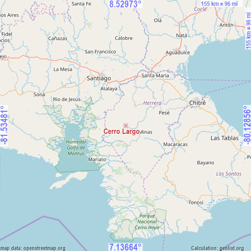
Cerro Largo GPS coordinates[2]
7° 50' 1.572" North, 80° 49' 54.048" West
| Map corner | latitude | longitude |
|---|---|---|
| Upper-left | 8.52973°, | -81.53481° |
| Center: | 7.83377°, | -80.83168° |
| Lower-right: | 7.13664°, | -80.12856° |
| Map W x H: | 154.9×154.9 km | = 96.3×96.3mi |
| max Lat: | 9.60898° ⇑88.4% North |
| Cerro Largo: | 7.83377° |
| min Lat: | ⇓11.6% South 7.26534° |
| min Long | Cerro Largo | max Long |
| -82.91275° | -80.83168° | -77.38965° |
| W 42.4%⇐ | ⇒57.6% E |
Elevation
Elevation of Cerro Largo is 386 m = 1266 ft, and this is 213.9 m = 702 ft above average elevation for this country.
| Max E: |
2103 m = 6900 ft | 12.6% |
| Cerro Largo | 386 m 1266 ft | |
| Avg. | 172.1 m = 565 ft | |
Min E: |
-1 m = -3 ft | 87.4% |
See also: Panama elevation on elevation.city.
Geographical zone
Cerro Largo is located in North Torrid zone (between Equator and Tropic of Cancer). Distance of Equator is 871 km =541.2 mi to South.| Distance of | km | miles | from Cerro Largo |
|---|---|---|---|
| North Pole | 9136 | 5676.8 | to North |
| Arctic Circle | 6530.1 | 4057.6 | to North |
| Tropic Cancer | 1734.9 | 1078 | to North |
| Equator | 871 | 541.2 | to South |


Nearby cities:
15 places around Cerro Largo: (largest is in red/bold)
• Cabuya
18.1 km =11.2 mi,  24°
24°
• Chumical
11.7 km =7.3 mi,  83°
83°
• El Barrito
19.1 km =11.9 mi,  317°
317°
• El Toro
10.1 km =6.3 mi,  204°
204°
• La Carrillo
16.1 km =10 mi,  339°
339°
• La Trinidad
16.8 km =10.4 mi,  57°
57°
• Las Guabas
8.8 km =5.5 mi, 17°
• Las Minas
10.4 km =6.5 mi,  114°
114°
• Leones Arriba
7.7 km =4.8 mi,  191°
191°
• Limón de Tijeras
9.2 km =5.7 mi,  258°
258°
• Ocú
13.2 km =8.2 mi,  25°
25°
• Peñas Chatas
20.4 km =12.7 mi,  8°
8°
• Ponuga
17.1 km =10.6 mi,  288°
288°
• Quebrada del Rosario
16.7 km =10.4 mi,  143°
143°
• San José
13.2 km =8.2 mi,  352°
352°
Sources, notices
• [Note1] Compared only with cities in Panama existing in our database
• [Src1] Map data: © OpenStreetMap contributors (CC-BY-SA)
• [Src2] Other city data from geonames.org with taken over terms of usage.
• [Src3] Geographical zone / Annual Mean Temperature by Robert A. Rohde @ Wikipedia
