Ocú geodata
Ocú (Herrera) is a seat of a second-order administrative division; located in Panama in America/Panama (GMT-5) time zone. With population of 3,939 people, there are 78 cities with bigger population in this country. Compared to other cities in Panama, 84.8% of cities are located further ↑North; 56.4% of cities are located further →East and 64.4% of cities have lower elevation than Ocú. Note1


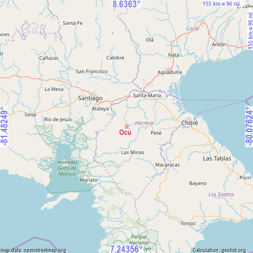
Ocú GPS coordinates[2]
7° 56' 25.872" North, 80° 46' 45.696" West
| Map corner | latitude | longitude |
|---|---|---|
| Upper-left | 8.6363°, | -81.48249° |
| Center: | 7.94052°, | -80.77936° |
| Lower-right: | 7.24356°, | -80.07624° |
| Map W x H: | 154.9×154.9 km | = 96.3×96.3mi |
| max Lat: | 9.60898° ⇑84.8% North |
| Ocú: | 7.94052° |
| min Lat: | ⇓15.2% South 7.26534° |
| min Long | Ocú | max Long |
| -82.91275° | -80.77936° | -77.38965° |
| W 43.6%⇐ | ⇒56.4% E |
Elevation
Elevation of Ocú is 122 m = 400 ft, and this is 50.1 m = 164 ft below average elevation for this country.
| Max E: |
2103 m = 6900 ft | 35.6% |
| Avg. | 172.1 m = 565 ft | |
| Ocú | 122 m = 400 ft | |
Min E: |
-1 m = -3 ft | 64.4% |
See also: Panama elevation on elevation.city.
Geographical zone
Ocú is located in North Torrid zone (between Equator and Tropic of Cancer). Distance of Equator is 882.9 km =548.6 mi to South.| Distance of | km | miles | from Ocú |
|---|---|---|---|
| North Pole | 9124.2 | 5669.5 | to North |
| Arctic Circle | 6518.3 | 4050.3 | to North |
| Tropic Cancer | 1723 | 1070.6 | to North |
| Equator | 882.9 | 548.6 | to South |


Nearby cities:
15 places around Ocú: (largest is in red/bold)
• Cabuya
5 km =3.1 mi,  19°
19°
• Cerro Largo
13.2 km =8.2 mi,  205°
205°
• Chumical
12.1 km =7.5 mi,  151°
151°
• Chupampa
15.1 km =9.4 mi,  1°
1°
• El Limón
13.1 km =8.1 mi, 3°
• El Pedregoso
15.6 km =9.7 mi,  91°
91°
• La Carrillo
11.9 km =7.4 mi,  285°
285°
• La Montañuela
13.2 km =8.2 mi,  315°
315°
• La Trinidad
8.9 km =5.5 mi,  109°
109°
• Las Guabas
4.6 km =2.9 mi,  221°
221°
• Las Minas
16.5 km =10.3 mi,  167°
167°
• Llano Grande
8.4 km =5.2 mi,  63°
63°
• Llano de La Cruz
15.1 km =9.4 mi, 85°
• Peñas Chatas
8.7 km =5.4 mi,  342°
342°
• San José
7.6 km =4.7 mi,  279°
279°
Sources, notices
• [Note1] Compared only with cities in Panama existing in our database
• [Src1] Map data: © OpenStreetMap contributors (CC-BY-SA)
• [Src2] Other city data from geonames.org with taken over terms of usage.
• [Src3] Geographical zone / Annual Mean Temperature by Robert A. Rohde @ Wikipedia
