Chumical geodata
Chumical (Herrera) is a seat of a third-order administrative division; located in Panama in America/Panama (GMT-5) time zone. With population of 433 people, there are 508 cities with bigger population in this country. Compared to other cities in Panama, 87.8% of cities are located further ↑North; 55.2% of cities are located further →East and 65.9% of cities have lower elevation than Chumical. Note1


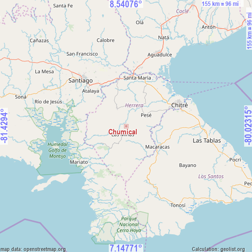
Chumical GPS coordinates[2]
7° 50' 41.352" North, 80° 43' 34.572" West
| Map corner | latitude | longitude |
|---|---|---|
| Upper-left | 8.54076°, | -81.4294° |
| Center: | 7.84482°, | -80.72627° |
| Lower-right: | 7.14771°, | -80.02315° |
| Map W x H: | 154.9×154.9 km | = 96.3×96.3mi |
| max Lat: | 9.60898° ⇑87.8% North |
| Chumical: | 7.84482° |
| min Lat: | ⇓12.2% South 7.26534° |
| min Long | Chumical | max Long |
| -82.91275° | -80.72627° | -77.38965° |
| W 44.8%⇐ | ⇒55.2% E |
Elevation
Elevation of Chumical is 128 m = 420 ft, and this is 44.1 m = 145 ft below average elevation for this country.
| Max E: |
2103 m = 6900 ft | 34.1% |
| Avg. | 172.1 m = 565 ft | |
| Chumical | 128 m = 420 ft | |
Min E: |
-1 m = -3 ft | 65.9% |
See also: Panama elevation on elevation.city.
Geographical zone
Chumical is located in North Torrid zone (between Equator and Tropic of Cancer). Distance of Equator is 872.3 km =542 mi to South.| Distance of | km | miles | from Chumical |
|---|---|---|---|
| North Pole | 9134.8 | 5676.1 | to North |
| Arctic Circle | 6528.9 | 4056.9 | to North |
| Tropic Cancer | 1733.7 | 1077.3 | to North |
| Equator | 872.3 | 542 | to South |


Nearby cities:
15 places around Chumical: (largest is in red/bold)
• Cerro Largo
11.7 km =7.3 mi,  263°
263°
• El Pedregoso
14.1 km =8.8 mi,  43°
43°
• La Trinidad
8.2 km =5.1 mi,  18°
18°
• Las Guabas
11.4 km =7.1 mi,  308°
308°
• Las Minas
5.9 km =3.7 mi,  201°
201°
• Llano Grande
14.5 km =9 mi,  6°
6°
• Llano de La Cruz
15.1 km =9.4 mi, 37°
• Los Cerritos
13.8 km =8.6 mi,  112°
112°
• Los Cerros de Paja
15.3 km =9.5 mi,  157°
157°
• Los Pozos
11.3 km =7 mi,  127°
127°
• Ocú
12.1 km =7.5 mi,  331°
331°
• Pesé
14.2 km =8.8 mi,  60°
60°
• Quebrada del Rosario
14.8 km =9.2 mi,  186°
186°
• Rincón Hondo
13.5 km =8.4 mi,  90°
90°
• Sabana Grande
10.5 km =6.5 mi,  68°
68°
Sources, notices
• [Note1] Compared only with cities in Panama existing in our database
• [Src1] Map data: © OpenStreetMap contributors (CC-BY-SA)
• [Src2] Other city data from geonames.org with taken over terms of usage.
• [Src3] Geographical zone / Annual Mean Temperature by Robert A. Rohde @ Wikipedia
