Los Chiricanos geodata
Los Chiricanos (Bocas del Toro) is a populated place; located in Panama in America/Panama (GMT-5) time zone. With population of 513 people, there are 478 cities with bigger population in this country. Compared to other cities in Panama, 83.1% of cities are located further ↓South; 81% of cities are located further →East and 96.3% of cities have higher elevation than Los Chiricanos. Note1


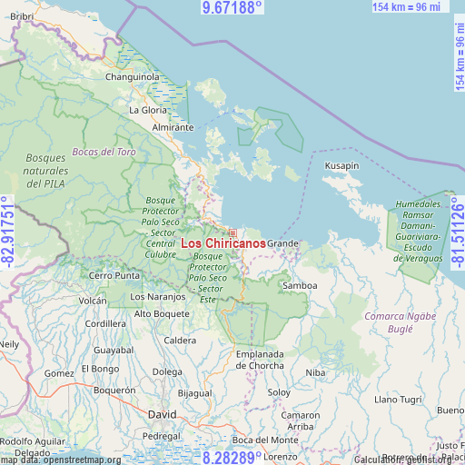
Los Chiricanos GPS coordinates[2]
8° 58' 40.98" North, 82° 12' 51.768" West
| Map corner | latitude | longitude |
|---|---|---|
| Upper-left | 9.67188°, | -82.91751° |
| Center: | 8.97805°, | -82.21438° |
| Lower-right: | 8.28289°, | -81.51126° |
| Map W x H: | 154.4×154.4 km | = 95.9×95.9mi |
| max Lat: | 9.60898° ⇑16.9% North |
| Los Chiricanos: | 8.97805° |
| min Lat: | ⇓83.1% South 7.26534° |
| min Long | Los Chiricanos | max Long |
| -82.91275° | -82.21438° | -77.38965° |
| W 19%⇐ | ⇒81% E |
Elevation
Elevation of Los Chiricanos is 6 m = 20 ft, and this is 166.1 m = 545 ft below average elevation for this country.
| Max E: |
2103 m = 6900 ft | 96.3% |
| Avg. | 172.1 m = 565 ft | |
| Los Chiricanos | 6 m = 20 ft | |
Min E: |
-1 m = -3 ft | 3.7% |
See also: Panama elevation on elevation.city.
Geographical zone
Los Chiricanos is located in North Torrid zone (between Equator and Tropic of Cancer). Distance of Equator is 998.3 km =620.3 mi to South.| Distance of | km | miles | from Los Chiricanos |
|---|---|---|---|
| North Pole | 9008.8 | 5597.8 | to North |
| Arctic Circle | 6402.9 | 3978.6 | to North |
| Tropic Cancer | 1607.7 | 999 | to North |
| Equator | 998.3 | 620.3 | to South |


Nearby cities:
15 places around Los Chiricanos: (largest is in red/bold)
• Alto Lino
31.3 km =19.4 mi,  230°
230°
• Cauchero
20.1 km =12.5 mi,  344°
344°
• Cayo de Agua
25.9 km =16.1 mi,  42°
42°
• Chiriquí Grande
11.2 km =7 mi,  108°
108°
• Isla Tigre
26.4 km =16.4 mi,  33°
33°
• Jaramillo Arriba
30.6 km =19 mi, 228°
• Miramar
3.5 km =2.2 mi,  302°
302°
• Norteño
11.4 km =7.1 mi,  284°
284°
• Pueblo Nuevo
10.9 km =6.8 mi,  185°
185°
• Punta Laurel
20.5 km =12.7 mi, 27°
• Punta Peña
7.6 km =4.7 mi,  154°
154°
• Punta Róbalo
7.5 km =4.7 mi,  329°
329°
• Quebrada Pastor
30.4 km =18.9 mi, 328°
• Quebrada Tula
28.4 km =17.6 mi,  122°
122°
• Rámbala
7.4 km =4.6 mi, 149°
Sources, notices
• [Note1] Compared only with cities in Panama existing in our database
• [Src1] Map data: © OpenStreetMap contributors (CC-BY-SA)
• [Src2] Other city data from geonames.org with taken over terms of usage.
• [Src3] Geographical zone / Annual Mean Temperature by Robert A. Rohde @ Wikipedia
