La Palma geodata
La Palma (Darién) is a seat of a first-order administrative division; located in Panama in America/Panama (GMT-5) time zone. With population of 1,728 people, there are 137 cities with bigger population in this country. Compared to other cities in Panama, 56.8% of cities are located further ↑North; 96.1% of cities are located further ←West and 60.2% of cities have higher elevation than La Palma. Note1


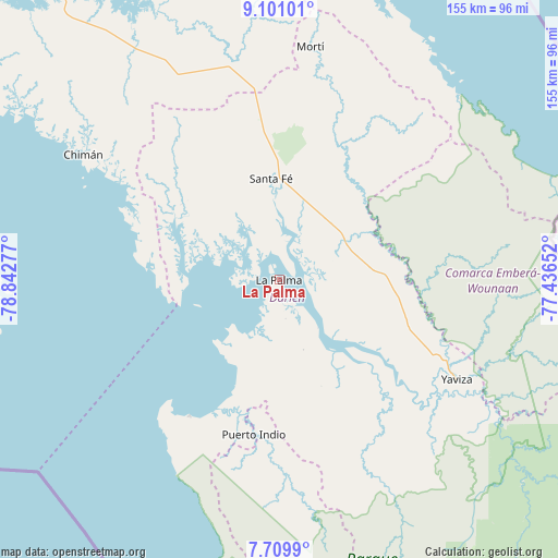
La Palma GPS coordinates[2]
8° 24' 21.888" North, 78° 8' 22.704" West
| Map corner | latitude | longitude |
|---|---|---|
| Upper-left | 9.10101°, | -78.84277° |
| Center: | 8.40608°, | -78.13964° |
| Lower-right: | 7.7099°, | -77.43652° |
| Map W x H: | 154.7×154.7 km | = 96.1×96.1mi |
| max Lat: | 9.60898° ⇑56.8% North |
| La Palma: | 8.40608° |
| min Lat: | ⇓43.2% South 7.26534° |
| min Long | La Palma | max Long |
| -82.91275° | -78.13964° | -77.38965° |
| W 96.1%⇐ | ⇒3.9% E |
Elevation
Elevation of La Palma is 52 m = 171 ft, and this is 120.1 m = 394 ft below average elevation for this country.
| Max E: |
2103 m = 6900 ft | 60.2% |
| Avg. | 172.1 m = 565 ft | |
| La Palma | 52 m = 171 ft | |
Min E: |
-1 m = -3 ft | 39.8% |
See also: Panama elevation on elevation.city.
Geographical zone
La Palma is located in North Torrid zone (between Equator and Tropic of Cancer). Distance of Equator is 934.7 km =580.8 mi to South.| Distance of | km | miles | from La Palma |
|---|---|---|---|
| North Pole | 9072.4 | 5637.3 | to North |
| Arctic Circle | 6466.5 | 4018.1 | to North |
| Tropic Cancer | 1671.3 | 1038.5 | to North |
| Equator | 934.7 | 580.8 | to South |


Nearby cities:
15 places around La Palma: (largest is in red/bold)
• Barriales
33.7 km =20.9 mi,  305°
305°
• Chepigana
16.5 km =10.3 mi,  144°
144°
• Cucunatí
22.8 km =14.2 mi,  325°
325°
• Gonzalo Vásquez
34.8 km =21.6 mi,  271°
271°
• Lajas Blancas
36.1 km =22.4 mi,  88°
88°
• Metetí
20.5 km =12.7 mi,  59°
59°
• Pueblo Nuevo
30.9 km =19.2 mi,  203°
203°
• Puerto Indio
43.3 km =26.9 mi,  189°
189°
• Punta Alegre
17.6 km =10.9 mi,  225°
225°
• Quebrada Honda
25.7 km =16 mi,  6°
6°
• Sambú
43 km =26.7 mi, 190°
• Santa Fé
27.8 km =17.3 mi,  355°
355°
• Setegantí
13.2 km =8.2 mi,  160°
160°
• Villa Darién
21.2 km =13.2 mi,  43°
43°
• Zapallal
27.1 km =16.8 mi,  2°
2°
Sources, notices
• [Note1] Compared only with cities in Panama existing in our database
• [Src1] Map data: © OpenStreetMap contributors (CC-BY-SA)
• [Src2] Other city data from geonames.org with taken over terms of usage.
• [Src3] Geographical zone / Annual Mean Temperature by Robert A. Rohde @ Wikipedia
