Uchiza geodata
Uchiza (San Martín) is a seat of a third-order administrative division; located in Peru in America/Lima (GMT-5) time zone. With population of 17,742 people, there are 89 cities with bigger population in this country. Compared to other cities in Peru, 71% of cities are located further ↓South; 58.9% of cities are located further →East and 77.2% of cities have higher elevation than Uchiza. Note1


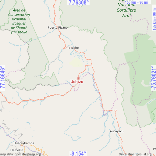
Uchiza GPS coordinates[2]
8° 27' 33.012" South, 76° 27' 47.988" West
| Map corner | latitude | longitude |
|---|---|---|
| Upper-left | -7.76308°, | -77.16646° |
| Center: | -8.45917°, | -76.46333° |
| Lower-right: | -9.154°, | -75.76021° |
| Map W x H: | 154.7×154.7 km | = 96.1×96.1mi |
| max Lat: | -0.96667° ⇑29% North |
| Uchiza: | -8.45917° |
| min Lat: | ⇓71% South -18.01465° |
| min Long | Uchiza | max Long |
| -81.30472° | -76.46333° | -69.04167° |
| W 41.1%⇐ | ⇒58.9% E |
Elevation
Elevation of Uchiza is 563 m = 1847 ft, and this is 1755.7 m = 5760 ft below average elevation for this country.
| Max E: |
5022 m = 16476 ft | 77.2% |
| Avg. | 2318.7 m = 7607 ft | |
| Uchiza | 563 m = 1847 ft | |
Min E: |
1 m = 3 ft | 22.8% |
See also: Peru elevation on elevation.city.
Geographical zone
Uchiza is located in South Torrid zone (between Equator and Tropic of Capricorn). Distance of Equator is 940.6 km =584.5 mi to North.| Distance of | km | miles | from Uchiza |
|---|---|---|---|
| Equator | 940.6 | 584.5 | to North |
| Tropic Capricorn | 1665.3 | 1034.8 | to South |
| Antarctic Circle | 6460.6 | 4014.4 | to South |
| South Pole | 9066.5 | 5633.7 | to South |


Nearby cities:
15 places around Uchiza: (largest is in red/bold)
• Arancay
85.3 km =53 mi,  201°
201°
• Aucayacu
65.1 km =40.5 mi,  143°
143°
• Challas
94.3 km =58.6 mi,  271°
271°
• Chingas
93.6 km =58.2 mi,  218°
218°
• Cochabamba
81.8 km =50.8 mi,  210°
210°
• Huacaybamba
83.9 km =52.1 mi, 219°
• Huacchis
89.8 km =55.8 mi, 203°
• Huacrachuco
71.4 km =44.4 mi,  252°
252°
• Huancaspata
91.8 km =57 mi, 270°
• Nuevo Progreso
15.4 km =9.6 mi,  87°
87°
• Paucas
90.7 km =56.4 mi, 211°
• Rapayan
88.9 km =55.2 mi, 201°
• Tayabamba
93.9 km =58.3 mi,  282°
282°
• Tocache
30.8 km =19.1 mi,  348°
348°
• Uco
95.8 km =59.5 mi, 212°
Sources, notices
• [Note1] Compared only with cities in Peru existing in our database
• [Src1] Map data: © OpenStreetMap contributors (CC-BY-SA)
• [Src2] Other city data from geonames.org with taken over terms of usage.
• [Src3] Geographical zone / Annual Mean Temperature by Robert A. Rohde @ Wikipedia
