Aucayacu geodata
Aucayacu (Huanuco) is a seat of a third-order administrative division; located in Peru in America/Lima (GMT-5) time zone. In our database, there are 305 cities with bigger population. Compared to other cities in Peru, 69.4% of cities are located further ↓South; 53.6% of cities are located further →East and 77% of cities have higher elevation than Aucayacu. Note1
Administrative division(s):
- Level 1: Huanuco
- Level 2: Provincia de Leoncio Prado
- Level 3: Jose Crespo Y Castillo


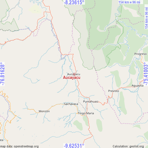
Aucayacu GPS coordinates[2]
8° 55' 53.004" South, 76° 6' 47.34" West
| Map corner | latitude | longitude |
|---|---|---|
| Upper-left | -8.23615°, | -76.81628° |
| Center: | -8.93139°, | -76.11315° |
| Lower-right: | -9.62531°, | -75.41003° |
| Map W x H: | 154.5×154.5 km | = 96×96mi |
| max Lat: | -0.96667° ⇑30.6% North |
| Aucayacu: | -8.93139° |
| min Lat: | ⇓69.4% South -18.01465° |
| min Long | Aucayacu | max Long |
| -81.30472° | -76.11315° | -69.04167° |
| W 46.4%⇐ | ⇒53.6% E |
Elevation
Elevation of Aucayacu is 569 m = 1867 ft, and this is 1749.7 m = 5740 ft below average elevation for this country.
| Max E: |
5022 m = 16476 ft | 77% |
| Avg. | 2318.7 m = 7607 ft | |
| Aucayacu | 569 m = 1867 ft | |
Min E: |
1 m = 3 ft | 23% |
See also: Peru elevation on elevation.city.
Geographical zone
Aucayacu is located in South Torrid zone (between Equator and Tropic of Capricorn). Distance of Equator is 993.1 km =617.1 mi to North.| Distance of | km | miles | from Aucayacu |
|---|---|---|---|
| Equator | 993.1 | 617.1 | to North |
| Tropic Capricorn | 1612.8 | 1002.1 | to South |
| Antarctic Circle | 6408.1 | 3981.8 | to South |
| South Pole | 9014 | 5601 | to South |


Nearby cities:
15 places around Aucayacu: (largest is in red/bold)
• Arancay
74.8 km =46.5 mi,  249°
249°
• Cochabamba
81.5 km =50.6 mi,  257°
257°
• Huacaybamba
93 km =57.8 mi, 262°
• Huacchis
79.9 km =49.6 mi, 248°
• Las Palmas
51.7 km =32.1 mi,  166°
166°
• Llata
91.2 km =56.7 mi,  233°
233°
• Nuevo Progreso
58.1 km =36.1 mi,  336°
336°
• Paucas
89.7 km =55.7 mi, 254°
• Rapayan
77.1 km =47.9 mi, 246°
• Singa
92 km =57.2 mi,  236°
236°
• Tantamayo
84.3 km =52.4 mi, 232°
• Tingo María
42.5 km =26.4 mi,  162°
162°
• Tocache
94 km =58.4 mi,  331°
331°
• Uchiza
65.1 km =40.5 mi,  323°
323°
• Uco
93.9 km =58.3 mi, 252°
Sources, notices
• [Note1] Compared only with cities in Peru existing in our database
• [Src1] Map data: © OpenStreetMap contributors (CC-BY-SA)
• [Src2] Other city data from geonames.org with taken over terms of usage.
• [Src3] Geographical zone / Annual Mean Temperature by Robert A. Rohde @ Wikipedia
