Requena geodata
Requena (Loreto) is a seat of a third-order administrative division; located in Peru in America/Lima (GMT-5) time zone. In our database, there are 305 cities with bigger population. Compared to other cities in Peru, 95.2% of cities are located further ↓South; 67.4% of cities are located further ←West and 89.2% of cities have higher elevation than Requena. Note1


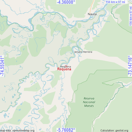
Requena GPS coordinates[2]
5° 3' 38.988" South, 73° 51' 1.008" West
| Map corner | latitude | longitude |
|---|---|---|
| Upper-left | -4.36008°, | -74.55341° |
| Center: | -5.06083°, | -73.85028° |
| Lower-right: | -5.76082°, | -73.14716° |
| Map W x H: | 155.7×155.8 km | = 96.7×96.8mi |
| max Lat: | -0.96667° ⇑4.8% North |
| Requena: | -5.06083° |
| min Lat: | ⇓95.2% South -18.01465° |
| min Long | Requena | max Long |
| -81.30472° | -73.85028° | -69.04167° |
| W 67.4%⇐ | ⇒32.6% E |
Elevation
Elevation of Requena is 108 m = 354 ft, and this is 2210.7 m = 7253 ft below average elevation for this country.
| Max E: |
5022 m = 16476 ft | 89.2% |
| Avg. | 2318.7 m = 7607 ft | |
| Requena | 108 m = 354 ft | |
Min E: |
1 m = 3 ft | 10.8% |
See also: Peru elevation on elevation.city.
Geographical zone
Requena is located in South Torrid zone (between Equator and Tropic of Capricorn). Distance of Equator is 562.7 km =349.6 mi to North.| Distance of | km | miles | from Requena |
|---|---|---|---|
| Equator | 562.7 | 349.6 | to North |
| Tropic Capricorn | 2043.2 | 1269.6 | to South |
| Antarctic Circle | 6838.5 | 4249.2 | to South |
| South Pole | 9444.4 | 5868.5 | to South |


Nearby cities:
15 places around Requena: (largest is in red/bold)
• Bretaña
53.1 km =33 mi,  244°
244°
• Concordia
117.1 km =72.8 mi,  297°
297°
• Genaro Herrera
26.5 km =16.5 mi,  49°
49°
• Iberia
75.1 km =46.7 mi,  206°
206°
• Indiana
194.9 km =121.1 mi,  27°
27°
• Iquitos
160.1 km =99.5 mi,  24°
24°
• Lagunas
202.9 km =126.1 mi,  264°
264°
• Nauta
67.4 km =41.9 mi, 29°
• Parinari
84.8 km =52.7 mi,  310°
310°
• San Juan
134.5 km =83.6 mi,  13°
13°
• Santa Elena
111.2 km =69.1 mi,  193°
193°
• Santa Isabel
107.7 km =66.9 mi,  223°
223°
• Saquena
57.3 km =35.6 mi,  40°
40°
• Tamanco
101.8 km =63.3 mi, 210°
• Trompeteros
192.7 km =119.7 mi,  315°
315°
Sources, notices
• [Note1] Compared only with cities in Peru existing in our database
• [Src1] Map data: © OpenStreetMap contributors (CC-BY-SA)
• [Src2] Other city data from geonames.org with taken over terms of usage.
• [Src3] Geographical zone / Annual Mean Temperature by Robert A. Rohde @ Wikipedia
