Papayal geodata
Papayal (Tumbes) is a seat of a third-order administrative division; located in Peru in America/Lima (GMT-5) time zone. In our database, there are 305 cities with bigger population. Compared to other cities in Peru, 99.4% of cities are located further ↓South; 97% of cities are located further →East and 94.6% of cities have higher elevation than Papayal. Note1


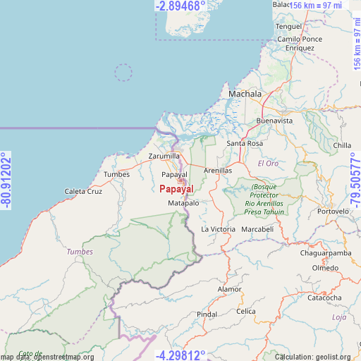
Papayal GPS coordinates[2]
3° 35' 48.012" South, 80° 12' 32.004" West
| Map corner | latitude | longitude |
|---|---|---|
| Upper-left | -2.89468°, | -80.91202° |
| Center: | -3.59667°, | -80.20889° |
| Lower-right: | -4.29812°, | -79.50577° |
| Map W x H: | 156×156.1 km | = 96.9×97mi |
| max Lat: | -0.96667° ⇑0.6% North |
| Papayal: | -3.59667° |
| min Lat: | ⇓99.4% South -18.01465° |
| min Long | Papayal | max Long |
| -81.30472° | -80.20889° | -69.04167° |
| W 3%⇐ | ⇒97% E |
Elevation
Elevation of Papayal is 33 m = 108 ft, and this is 2285.7 m = 7499 ft below average elevation for this country.
| Max E: |
5022 m = 16476 ft | 94.6% |
| Avg. | 2318.7 m = 7607 ft | |
| Papayal | 33 m = 108 ft | |
Min E: |
1 m = 3 ft | 5.4% |
See also: Peru elevation on elevation.city.
Geographical zone
Papayal is located in South Torrid zone (between Equator and Tropic of Capricorn). Distance of Equator is 399.9 km =248.5 mi to North.| Distance of | km | miles | from Papayal |
|---|---|---|---|
| Equator | 399.9 | 248.5 | to North |
| Tropic Capricorn | 2206 | 1370.7 | to South |
| Antarctic Circle | 7001.3 | 4350.4 | to South |
| South Pole | 9607.1 | 5969.6 | to South |


Nearby cities:
15 places around Papayal: (largest is in red/bold)
• Aguas Verdes
13.4 km =8.3 mi,  342°
342°
• Caleta Cruz
42.7 km =26.5 mi,  263°
263°
• Cancas
90.1 km =56 mi,  244°
244°
• Cañaveral
62.3 km =38.7 mi,  231°
231°
• La Breita
105 km =65.2 mi, 225°
• Las Lomas
117.6 km =73.1 mi,  182°
182°
• Matapalo
9.6 km =6 mi,  173°
173°
• Máncora
109 km =67.7 mi, 238°
• Paimas
118.2 km =73.4 mi, 165°
• Papayal
79.3 km =49.3 mi, 227°
• San Jacinto
27 km =16.8 mi, 259°
• Suyo
104.5 km =64.9 mi, 167°
• Tumbes
27.1 km =16.8 mi,  276°
276°
• Zarumilla
12.6 km =7.8 mi,  325°
325°
• Zorritos
52.9 km =32.9 mi, 259°
Sources, notices
• [Note1] Compared only with cities in Peru existing in our database
• [Src1] Map data: © OpenStreetMap contributors (CC-BY-SA)
• [Src2] Other city data from geonames.org with taken over terms of usage.
• [Src3] Geographical zone / Annual Mean Temperature by Robert A. Rohde @ Wikipedia
