Aguas Verdes geodata
Aguas Verdes (Tumbes) is a seat of a third-order administrative division; located in Peru in America/Lima (GMT-5) time zone. With population of 9,106 people, there are 154 cities with bigger population in this country. Compared to other cities in Peru, 99.7% of cities are located further ↓South; 97.1% of cities are located further →East and 99% of cities have higher elevation than Aguas Verdes. Note1


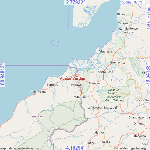
Aguas Verdes GPS coordinates[2]
3° 28' 53.004" South, 80° 14' 42" West
| Map corner | latitude | longitude |
|---|---|---|
| Upper-left | -2.77932°, | -80.94813° |
| Center: | -3.48139°, | -80.245° |
| Lower-right: | -4.18294°, | -79.54188° |
| Map W x H: | 156.1×156.1 km | = 97×97mi |
| max Lat: | -0.96667° ⇑0.3% North |
| Aguas Verdes: | -3.48139° |
| min Lat: | ⇓99.7% South -18.01465° |
| min Long | Aguas Verdes | max Long |
| -81.30472° | -80.245° | -69.04167° |
| W 2.9%⇐ | ⇒97.1% E |
Elevation
Elevation of Aguas Verdes is 9 m = 30 ft, and this is 2309.7 m = 7578 ft below average elevation for this country.
| Max E: |
5022 m = 16476 ft | 99% |
| Avg. | 2318.7 m = 7607 ft | |
| Aguas Verdes | 9 m = 30 ft | |
Min E: |
1 m = 3 ft | 1% |
See also: Peru elevation on elevation.city.
Geographical zone
Aguas Verdes is located in South Torrid zone (between Equator and Tropic of Capricorn). Distance of Equator is 387.1 km =240.5 mi to North.| Distance of | km | miles | from Aguas Verdes |
|---|---|---|---|
| Equator | 387.1 | 240.5 | to North |
| Tropic Capricorn | 2218.8 | 1378.7 | to South |
| Antarctic Circle | 7014.1 | 4358.4 | to South |
| South Pole | 9620 | 5977.6 | to South |


Nearby cities:
15 places around Aguas Verdes: (largest is in red/bold)
• Caleta Cruz
42.2 km =26.2 mi,  245°
245°
• Cancas
93 km =57.8 mi,  236°
236°
• Cañaveral
68.2 km =42.4 mi,  221°
221°
• La Breita
111.8 km =69.5 mi, 219°
• Las Lomas
130.3 km =81 mi,  180°
180°
• Los Organos
124.6 km =77.4 mi,  231°
231°
• Matapalo
23 km =14.3 mi,  167°
167°
• Máncora
113 km =70.2 mi, 231°
• Papayal
13.4 km =8.3 mi,  162°
162°
• Papayal
85.9 km =53.4 mi, 219°
• San Jacinto
28.7 km =17.8 mi, 231°
• Suyo
117.9 km =73.3 mi, 166°
• Tumbes
24.8 km =15.4 mi, 247°
• Zarumilla
3.9 km =2.4 mi, 232°
• Zorritos
52.9 km =32.9 mi, 245°
Sources, notices
• [Note1] Compared only with cities in Peru existing in our database
• [Src1] Map data: © OpenStreetMap contributors (CC-BY-SA)
• [Src2] Other city data from geonames.org with taken over terms of usage.
• [Src3] Geographical zone / Annual Mean Temperature by Robert A. Rohde @ Wikipedia
