Nepeña geodata
Nepeña (Ancash) is a seat of a third-order administrative division; located in Peru in America/Lima (GMT-5) time zone. In our database, there are 305 cities with bigger population. Compared to other cities in Peru, 67.6% of cities are located further ↓South; 84.4% of cities are located further →East and 87.4% of cities have higher elevation than Nepeña. Note1


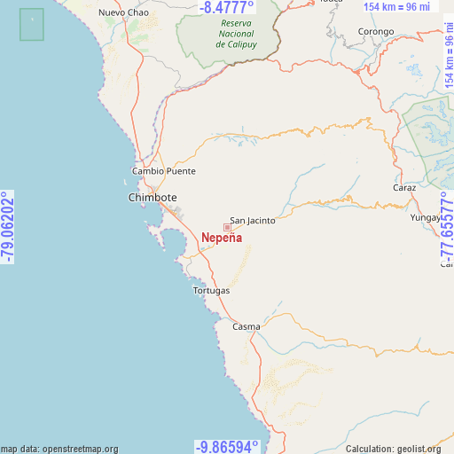
Nepeña GPS coordinates[2]
9° 10' 21" South, 78° 21' 32.004" West
| Map corner | latitude | longitude |
|---|---|---|
| Upper-left | -8.4777°, | -79.06202° |
| Center: | -9.1725°, | -78.35889° |
| Lower-right: | -9.86594°, | -77.65577° |
| Map W x H: | 154.4×154.4 km | = 95.9×95.9mi |
| max Lat: | -0.96667° ⇑32.4% North |
| Nepeña: | -9.1725° |
| min Lat: | ⇓67.6% South -18.01465° |
| min Long | Nepeña | max Long |
| -81.30472° | -78.35889° | -69.04167° |
| W 15.6%⇐ | ⇒84.4% E |
Elevation
Elevation of Nepeña is 142 m = 466 ft, and this is 2176.7 m = 7141 ft below average elevation for this country.
| Max E: |
5022 m = 16476 ft | 87.4% |
| Avg. | 2318.7 m = 7607 ft | |
| Nepeña | 142 m = 466 ft | |
Min E: |
1 m = 3 ft | 12.6% |
See also: Peru elevation on elevation.city.
Geographical zone
Nepeña is located in South Torrid zone (between Equator and Tropic of Capricorn). Distance of Equator is 1019.9 km =633.7 mi to North.| Distance of | km | miles | from Nepeña |
|---|---|---|---|
| Equator | 1019.9 | 633.7 | to North |
| Tropic Capricorn | 1586 | 985.5 | to South |
| Antarctic Circle | 6381.3 | 3965.2 | to South |
| South Pole | 8987.2 | 5584.4 | to South |


Nearby cities:
15 places around Nepeña: (largest is in red/bold)
• Buenos Aires
16.1 km =10 mi,  289°
289°
• Casma
34.2 km =21.3 mi,  169°
169°
• Chimbote
26 km =16.2 mi, 291°
• Coishco
32.7 km =20.3 mi,  300°
300°
• Guadalupito
38.1 km =23.7 mi,  310°
310°
• Huata
57.4 km =35.7 mi,  72°
72°
• Macate
54.3 km =33.7 mi,  33°
33°
• Moro
19.8 km =12.3 mi,  79°
79°
• Pamparomas
42.9 km =26.7 mi, 75°
• Puerto Casma
32.5 km =20.2 mi,  184°
184°
• Puerto Santa
37.7 km =23.4 mi, 302°
• Quillo
39 km =24.2 mi,  116°
116°
• Samanco
18 km =11.2 mi,  236°
236°
• Santa
34.5 km =21.4 mi, 306°
• Sucre
61.1 km =38 mi, 66°
Sources, notices
• [Note1] Compared only with cities in Peru existing in our database
• [Src1] Map data: © OpenStreetMap contributors (CC-BY-SA)
• [Src2] Other city data from geonames.org with taken over terms of usage.
• [Src3] Geographical zone / Annual Mean Temperature by Robert A. Rohde @ Wikipedia
