Acomayo geodata
Acomayo (Huanuco) is a seat of a third-order administrative division; located in Peru in America/Lima (GMT-5) time zone. In our database, there are 305 cities with bigger population. Compared to other cities in Peru, 62.5% of cities are located further ↓South; 53.4% of cities are located further →East and 64.3% of cities have higher elevation than Acomayo. Note1


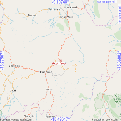
Acomayo GPS coordinates[2]
9° 48' 3.78" South, 76° 4' 18.984" West
| Map corner | latitude | longitude |
|---|---|---|
| Upper-left | -9.10748°, | -76.77507° |
| Center: | -9.80105°, | -76.07194° |
| Lower-right: | -10.49317°, | -75.36882° |
| Map W x H: | 154.1×154.1 km | = 95.8×95.8mi |
| max Lat: | -0.96667° ⇑37.5% North |
| Acomayo: | -9.80105° |
| min Lat: | ⇓62.5% South -18.01465° |
| min Long | Acomayo | max Long |
| -81.30472° | -76.07194° | -69.04167° |
| W 46.6%⇐ | ⇒53.4% E |
Elevation
Elevation of Acomayo is 2109 m = 6919 ft, and this is 209.7 m = 688 ft below average elevation for this country.
| Max E: |
5022 m = 16476 ft | 64.3% |
| Avg. | 2318.7 m = 7607 ft | |
| Acomayo | 2109 m = 6919 ft | |
Min E: |
1 m = 3 ft | 35.7% |
See also: Peru elevation on elevation.city.
Geographical zone
Acomayo is located in South Torrid zone (between Equator and Tropic of Capricorn). Distance of Equator is 1089.8 km =677.2 mi to North.| Distance of | km | miles | from Acomayo |
|---|---|---|---|
| Equator | 1089.8 | 677.2 | to North |
| Tropic Capricorn | 1516.1 | 942.1 | to South |
| Antarctic Circle | 6311.4 | 3921.7 | to South |
| South Pole | 8917.3 | 5541 | to South |


Nearby cities:
15 places around Acomayo: (largest is in red/bold)
• Ambo
39.4 km =24.5 mi,  201°
201°
• Cayhuayna
26.1 km =16.2 mi,  227°
227°
• Chaglla
19.1 km =11.9 mi,  104°
104°
• Chavinillo
59.1 km =36.7 mi,  263°
263°
• Churubamba
7.3 km =4.5 mi,  247°
247°
• Conchamarca
30.6 km =19 mi,  210°
210°
• Huacar
43.8 km =27.2 mi, 204°
• Huancapallac
38.9 km =24.2 mi, 254°
• Huánuco
23.6 km =14.7 mi, 232°
• Las Palmas
46.9 km =29.1 mi,  8°
8°
• Margos
54.4 km =33.8 mi, 245°
• Panao
13.8 km =8.6 mi,  141°
141°
• Paucarbamba
23 km =14.3 mi, 226°
• Tingo María
56.8 km =35.3 mi, 8°
• Tomay Kichwa
34.3 km =21.3 mi, 206°
Sources, notices
• [Note1] Compared only with cities in Peru existing in our database
• [Src1] Map data: © OpenStreetMap contributors (CC-BY-SA)
• [Src2] Other city data from geonames.org with taken over terms of usage.
• [Src3] Geographical zone / Annual Mean Temperature by Robert A. Rohde @ Wikipedia
