Subtanjalla geodata
Subtanjalla (Ica) is a seat of a third-order administrative division; located in Peru in America/Lima (GMT-5) time zone. With population of 9,096 people, there are 156 cities with bigger population in this country. Compared to other cities in Peru, 74.2% of cities are located further ↑North; 50.5% of cities are located further →East and 78.9% of cities have higher elevation than Subtanjalla. Note1


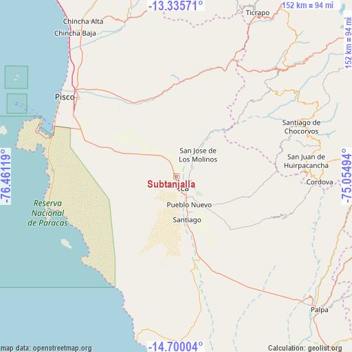
Subtanjalla GPS coordinates[2]
14° 1' 8.004" South, 75° 45' 29.016" West
| Map corner | latitude | longitude |
|---|---|---|
| Upper-left | -13.33571°, | -76.46119° |
| Center: | -14.01889°, | -75.75806° |
| Lower-right: | -14.70004°, | -75.05494° |
| Map W x H: | 151.7×151.7 km | = 94.3×94.3mi |
| max Lat: | -0.96667° ⇑74.2% North |
| Subtanjalla: | -14.01889° |
| min Lat: | ⇓25.8% South -18.01465° |
| min Long | Subtanjalla | max Long |
| -81.30472° | -75.75806° | -69.04167° |
| W 49.5%⇐ | ⇒50.5% E |
Elevation
Elevation of Subtanjalla is 428 m = 1404 ft, and this is 1890.7 m = 6203 ft below average elevation for this country.
| Max E: |
5022 m = 16476 ft | 78.9% |
| Avg. | 2318.7 m = 7607 ft | |
| Subtanjalla | 428 m = 1404 ft | |
Min E: |
1 m = 3 ft | 21.1% |
See also: Peru elevation on elevation.city.
Geographical zone
Subtanjalla is located in South Torrid zone (between Equator and Tropic of Capricorn). Distance of this Southern Tropic circle is 1047.2 km =650.7 mi to South.| Distance of | km | miles | from Subtanjalla |
|---|---|---|---|
| Equator | 1558.8 | 968.6 | to North |
| Tropic Capricorn | 1047.2 | 650.7 | to South |
| Antarctic Circle | 5842.4 | 3630.3 | to South |
| South Pole | 8448.3 | 5249.5 | to South |


Nearby cities:
15 places around Subtanjalla: (largest is in red/bold)
• Guadalupe
5.9 km =3.7 mi,  350°
350°
• Huancano
49 km =30.4 mi,  18°
18°
• Humay
36.9 km =22.9 mi,  335°
335°
• Ica
6.3 km =3.9 mi,  149°
149°
• Independencia
46.3 km =28.8 mi,  320°
320°
• La Tinguiña
6.5 km =4 mi,  106°
106°
• Los Aquijes
11.3 km =7 mi,  140°
140°
• Ocucaje
37.9 km =23.5 mi,  165°
165°
• Paracas
57.4 km =35.7 mi,  287°
287°
• Pueblo Nuevo
13.3 km =8.3 mi,  155°
155°
• Rosario de Yauca
23.7 km =14.7 mi,  123°
123°
• San Clemente
57.7 km =35.9 mi,  312°
312°
• San Juan Bautista
2.6 km =1.6 mi,  69°
69°
• Santiago
19.1 km =11.9 mi, 164°
• Villa Tupac Amaru
54.4 km =33.8 mi, 308°
Sources, notices
• [Note1] Compared only with cities in Peru existing in our database
• [Src1] Map data: © OpenStreetMap contributors (CC-BY-SA)
• [Src2] Other city data from geonames.org with taken over terms of usage.
• [Src3] Geographical zone / Annual Mean Temperature by Robert A. Rohde @ Wikipedia
