Ica geodata
Ica is a seat of a first-order administrative division; located in Peru in America/Lima (GMT-5) time zone. With population of 246,844 people, there are 13 cities with bigger population in this country. Compared to other cities in Peru, 75.1% of cities are located further ↑North; 50% of cities are located further ←West and 79.2% of cities have higher elevation than Ica. Note1


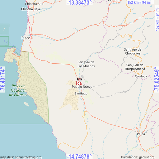
Ica GPS coordinates[2]
14° 4' 3.972" South, 75° 43' 42.996" West
| Map corner | latitude | longitude |
|---|---|---|
| Upper-left | -13.38473°, | -76.43174° |
| Center: | -14.06777°, | -75.72861° |
| Lower-right: | -14.74878°, | -75.02549° |
| Map W x H: | 151.7×151.7 km | = 94.3×94.3mi |
| max Lat: | -0.96667° ⇑75.1% North |
| Ica: | -14.06777° |
| min Lat: | ⇓24.9% South -18.01465° |
| min Long | Ica | max Long |
| -81.30472° | -75.72861° | -69.04167° |
| W 50%⇐ | ⇒50% E |
Elevation
Elevation of Ica is 408 m = 1339 ft, and this is 1910.7 m = 6269 ft below average elevation for this country.
| Max E: |
5022 m = 16476 ft | 79.2% |
| Avg. | 2318.7 m = 7607 ft | |
| Ica | 408 m = 1339 ft | |
Min E: |
1 m = 3 ft | 20.8% |
See also: Ica elevation on elevation.city.
Geographical zone
Ica is located in South Torrid zone (between Equator and Tropic of Capricorn). Distance of this Southern Tropic circle is 1041.7 km =647.3 mi to South.| Distance of | km | miles | from Ica |
|---|---|---|---|
| Equator | 1564.2 | 971.9 | to North |
| Tropic Capricorn | 1041.7 | 647.3 | to South |
| Antarctic Circle | 5837 | 3626.9 | to South |
| South Pole | 8442.9 | 5246.2 | to South |


Nearby cities:
15 places around Ica: (largest is in red/bold)
• Guadalupe
12 km =7.5 mi,  339°
339°
• Huancano
53.4 km =33.2 mi,  13°
13°
• Humay
43.2 km =26.8 mi,  334°
334°
• Independencia
52.5 km =32.6 mi,  321°
321°
• La Tinguiña
4.7 km =2.9 mi,  40°
40°
• Los Aquijes
5.2 km =3.2 mi,  128°
128°
• Ocucaje
31.9 km =19.8 mi,  168°
168°
• Paracas
62.2 km =38.6 mi,  291°
291°
• Pueblo Nuevo
7.1 km =4.4 mi,  160°
160°
• Rosario de Yauca
18.3 km =11.4 mi,  114°
114°
• San Juan Bautista
6.4 km =4 mi,  352°
352°
• Santiago
13.1 km =8.1 mi, 171°
• Subtanjalla
6.3 km =3.9 mi, 329°
• Tibillo
60.1 km =37.3 mi,  92°
92°
• Villa Tupac Amaru
60.3 km =37.5 mi,  311°
311°
Sources, notices
• [Note1] Compared only with cities in Peru existing in our database
• [Src1] Map data: © OpenStreetMap contributors (CC-BY-SA)
• [Src2] Other city data from geonames.org with taken over terms of usage.
• [Src3] Geographical zone / Annual Mean Temperature by Robert A. Rohde @ Wikipedia
