Los Aquijes geodata
Los Aquijes (Ica) is a seat of a third-order administrative division; located in Peru in America/Lima (GMT-5) time zone. With population of 7,848 people, there are 173 cities with bigger population in this country. Compared to other cities in Peru, 75.9% of cities are located further ↑North; 50.4% of cities are located further ←West and 79% of cities have higher elevation than Los Aquijes. Note1


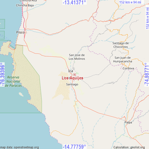
Los Aquijes GPS coordinates[2]
14° 5' 48.012" South, 75° 41' 26.988" West
| Map corner | latitude | longitude |
|---|---|---|
| Upper-left | -13.41371°, | -76.39396° |
| Center: | -14.09667°, | -75.69083° |
| Lower-right: | -14.77759°, | -74.98771° |
| Map W x H: | 151.6×151.7 km | = 94.2×94.3mi |
| max Lat: | -0.96667° ⇑75.9% North |
| Los Aquijes: | -14.09667° |
| min Lat: | ⇓24.1% South -18.01465° |
| min Long | Los Aquijes | max Long |
| -81.30472° | -75.69083° | -69.04167° |
| W 50.4%⇐ | ⇒49.6% E |
Elevation
Elevation of Los Aquijes is 418 m = 1371 ft, and this is 1900.7 m = 6236 ft below average elevation for this country.
| Max E: |
5022 m = 16476 ft | 79% |
| Avg. | 2318.7 m = 7607 ft | |
| Los Aquijes | 418 m = 1371 ft | |
Min E: |
1 m = 3 ft | 21% |
See also: Peru elevation on elevation.city.
Geographical zone
Los Aquijes is located in South Torrid zone (between Equator and Tropic of Capricorn). Distance of this Southern Tropic circle is 1038.5 km =645.3 mi to South.| Distance of | km | miles | from Los Aquijes |
|---|---|---|---|
| Equator | 1567.4 | 973.9 | to North |
| Tropic Capricorn | 1038.5 | 645.3 | to South |
| Antarctic Circle | 5833.8 | 3625 | to South |
| South Pole | 8439.7 | 5244.2 | to South |


Nearby cities:
15 places around Los Aquijes: (largest is in red/bold)
• Guadalupe
16.6 km =10.3 mi,  330°
330°
• Huancano
55.8 km =34.7 mi,  8°
8°
• Humay
47.9 km =29.8 mi, 331°
• Ica
5.2 km =3.2 mi,  308°
308°
• Independencia
57.5 km =35.7 mi,  320°
320°
• La Tinguiña
6.8 km =4.2 mi,  351°
351°
• Ocucaje
28.1 km =17.5 mi,  175°
175°
• Paracas
67.2 km =41.8 mi,  292°
292°
• Pueblo Nuevo
3.9 km =2.4 mi,  206°
206°
• Rosario de Yauca
13.3 km =8.3 mi,  108°
108°
• San Juan Bautista
10.7 km =6.6 mi, 333°
• Santiago
10 km =6.2 mi,  192°
192°
• Subtanjalla
11.3 km =7 mi, 320°
• Tibillo
56 km =34.8 mi,  89°
89°
• Villa Tupac Amaru
65.5 km =40.7 mi, 310°
Sources, notices
• [Note1] Compared only with cities in Peru existing in our database
• [Src1] Map data: © OpenStreetMap contributors (CC-BY-SA)
• [Src2] Other city data from geonames.org with taken over terms of usage.
• [Src3] Geographical zone / Annual Mean Temperature by Robert A. Rohde @ Wikipedia
