Baloy geodata
Baloy (Central Luzon) is a populated place; located in Philippines in Asia/Manila (GMT+8) time zone. With population of 2,308 people, there are 3661 cities with bigger population in this country. Compared to other cities in Philippines, 84.9% of cities are located further ↓South; 83% of cities are located further →East and 78.9% of cities have lower elevation than Baloy. Note1


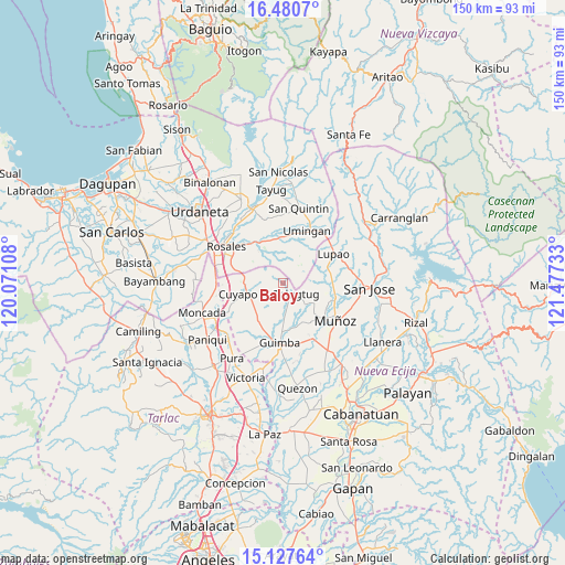
Baloy GPS coordinates[2]
15° 48' 19.08" North, 120° 46' 27.12" East
| Map corner | latitude | longitude |
|---|---|---|
| Upper-left | 16.4807°, | 120.07108° |
| Center: | 15.8053°, | 120.7742° |
| Lower-right: | 15.12764°, | 121.47733° |
| Map W x H: | 150.4×150.4 km | = 93.5×93.5mi |
| max Lat: | 20.78733° ⇑15.1% North |
| Baloy: | 15.8053° |
| min Lat: | ⇓84.9% South 4.65442° |
| min Long | Baloy | max Long |
| 117.04868° | 120.7742° | 126.58417° |
| W 17%⇐ | ⇒83% E |
Elevation
Elevation of Baloy is 85 m = 279 ft, and this is 2.9 m = 10 ft below average elevation for this country.
| Max E: |
2262 m = 7421 ft | 21.1% |
| Avg. | 87.9 m = 288 ft | |
| Baloy | 85 m = 279 ft | |
Min E: |
-2 m = -7 ft | 78.9% |
See also: Philippines elevation on elevation.city.
Geographical zone
Baloy is located in North Torrid zone (between Equator and Tropic of Cancer). Distance of this Northern Tropic circle is 848.5 km =527.2 mi to North.| Distance of | km | miles | from Baloy |
|---|---|---|---|
| North Pole | 8249.7 | 5126.1 | to North |
| Arctic Circle | 5643.8 | 3506.9 | to North |
| Tropic Cancer | 848.5 | 527.2 | to North |
| Equator | 1757.4 | 1092 | to South |


Nearby cities:
15 places around Baloy: (largest is in red/bold)
• Balungao
13.8 km =8.6 mi,  318°
318°
• Bued
13.7 km =8.5 mi,  284°
284°
• Calancuasan Norte
14.3 km =8.9 mi,  268°
268°
• Cavite
14.2 km =8.8 mi,  181°
181°
• Cuyapo
12 km =7.5 mi,  257°
257°
• Diaz
7.9 km =4.9 mi,  54°
54°
• Esmeralda
9.4 km =5.8 mi, 317°
• Lennec
14.2 km =8.8 mi,  197°
197°
• Lupao
15.6 km =9.7 mi,  58°
58°
• Paitan Norte
4.7 km =2.9 mi,  311°
311°
• Sampaloc
10 km =6.2 mi,  82°
82°
• San Andres
9.6 km =6 mi, 177°
• Talugtug
5 km =3.1 mi,  127°
127°
• Umingan
10.9 km =6.8 mi,  13°
13°
• Villa Isla
10.6 km =6.6 mi,  111°
111°
Sources, notices
• [Note1] Compared only with cities in Philippines existing in our database
• [Src1] Map data: © OpenStreetMap contributors (CC-BY-SA)
• [Src2] Other city data from geonames.org with taken over terms of usage.
• [Src3] Geographical zone / Annual Mean Temperature by Robert A. Rohde @ Wikipedia
