Paitan Norte geodata
Paitan Norte (Central Luzon) is a populated place; located in Philippines in Asia/Manila (GMT+8) time zone. With population of 2,586 people, there are 3135 cities with bigger population in this country. Compared to other cities in Philippines, 85.2% of cities are located further ↓South; 83.8% of cities are located further →East and 77.7% of cities have lower elevation than Paitan Norte. Note1


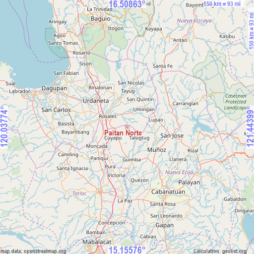
Paitan Norte GPS coordinates[2]
15° 49' 59.988" North, 120° 44' 27.096" East
| Map corner | latitude | longitude |
|---|---|---|
| Upper-left | 16.50863°, | 120.03774° |
| Center: | 15.83333°, | 120.74086° |
| Lower-right: | 15.15576°, | 121.44399° |
| Map W x H: | 150.4×150.4 km | = 93.5×93.5mi |
| max Lat: | 20.78733° ⇑14.8% North |
| Paitan Norte: | 15.83333° |
| min Lat: | ⇓85.2% South 4.65442° |
| min Long | Paitan Norte | max Long |
| 117.04868° | 120.74086° | 126.58417° |
| W 16.2%⇐ | ⇒83.8% E |
Elevation
Elevation of Paitan Norte is 79 m = 259 ft, and this is 8.9 m = 29 ft below average elevation for this country.
| Max E: |
2262 m = 7421 ft | 22.3% |
| Avg. | 87.9 m = 288 ft | |
| Paitan Norte | 79 m = 259 ft | |
Min E: |
-2 m = -7 ft | 77.7% |
See also: Philippines elevation on elevation.city.
Geographical zone
Paitan Norte is located in North Torrid zone (between Equator and Tropic of Cancer). Distance of this Northern Tropic circle is 845.4 km =525.3 mi to North.| Distance of | km | miles | from Paitan Norte |
|---|---|---|---|
| North Pole | 8246.6 | 5124.2 | to North |
| Arctic Circle | 5640.7 | 3505 | to North |
| Tropic Cancer | 845.4 | 525.3 | to North |
| Equator | 1760.5 | 1093.9 | to South |


Nearby cities:
15 places around Paitan Norte: (largest is in red/bold)
• Baloy
4.7 km =2.9 mi,  131°
131°
• Balungao
9.1 km =5.7 mi,  322°
322°
• Bued
9.7 km =6 mi,  272°
272°
• Calancuasan Norte
11.3 km =7 mi,  251°
251°
• Capandanan
14.8 km =9.2 mi,  340°
340°
• Cuyapo
10 km =6.2 mi,  234°
234°
• Diaz
10.1 km =6.3 mi,  81°
81°
• Esmeralda
4.7 km =2.9 mi, 323°
• Guiling
13.5 km =8.4 mi, 274°
• Rosales
13.4 km =8.3 mi,  300°
300°
• Sampaloc
13.6 km =8.5 mi,  97°
97°
• San Andres
13.3 km =8.3 mi,  162°
162°
• San Manuel
14.6 km =9.1 mi, 254°
• Talugtug
9.7 km =6 mi, 129°
• Umingan
9.7 km =6 mi,  39°
39°
Sources, notices
• [Note1] Compared only with cities in Philippines existing in our database
• [Src1] Map data: © OpenStreetMap contributors (CC-BY-SA)
• [Src2] Other city data from geonames.org with taken over terms of usage.
• [Src3] Geographical zone / Annual Mean Temperature by Robert A. Rohde @ Wikipedia
