Liberty geodata
Liberty (Soccsksargen) is a populated place; located in Philippines in Asia/Manila (GMT+8) time zone. With population of 2,172 people, there are 3945 cities with bigger population in this country. Compared to other cities in Philippines, 96% of cities are located further ↑North; 87.3% of cities are located further ←West and 90.9% of cities have lower elevation than Liberty. Note1
Administrative division(s):
- Level 1: Soccsksargen
- Level 2: Province of South Cotabato
- Level 3: Tampakan


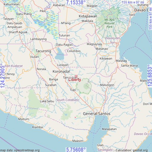
Liberty GPS coordinates[2]
6° 27' 18.756" North, 124° 58' 55.812" East
| Map corner | latitude | longitude |
|---|---|---|
| Upper-left | 7.15338°, | 124.27905° |
| Center: | 6.45521°, | 124.98217° |
| Lower-right: | 5.75608°, | 125.6853° |
| Map W x H: | 155.4×155.4 km | = 96.6×96.6mi |
| max Lat: | 20.78733° ⇑96% North |
| Liberty: | 6.45521° |
| min Lat: | ⇓4% South 4.65442° |
| min Long | Liberty | max Long |
| 117.04868° | 124.98217° | 126.58417° |
| W 87.3%⇐ | ⇒12.7% E |
Elevation
Elevation of Liberty is 250 m = 820 ft, and this is 162.1 m = 532 ft above average elevation for this country.
| Max E: |
2262 m = 7421 ft | 9.1% |
| Liberty | 250 m 820 ft | |
| Avg. | 87.9 m = 288 ft | |
Min E: |
-2 m = -7 ft | 90.9% |
See also: Philippines elevation on elevation.city.
Geographical zone
Liberty is located in North Torrid zone (between Equator and Tropic of Cancer). Distance of Equator is 717.8 km =446 mi to South.| Distance of | km | miles | from Liberty |
|---|---|---|---|
| North Pole | 9289.3 | 5772.1 | to North |
| Arctic Circle | 6683.4 | 4152.9 | to North |
| Tropic Cancer | 1888.2 | 1173.3 | to North |
| Equator | 717.8 | 446 | to South |


Nearby cities:
15 places around Liberty: (largest is in red/bold)
• Carpenter Hill
11.2 km =7 mi,  263°
263°
• Cebuano
7.6 km =4.7 mi,  191°
191°
• Kabalen
15.4 km =9.6 mi,  168°
168°
• Kipalbig
7.9 km =4.9 mi,  231°
231°
• Koronadal
15.9 km =9.9 mi,  289°
289°
• Lambayong
9.9 km =6.2 mi,  43°
43°
• Lampitak
8.2 km =5.1 mi,  108°
108°
• Linan
2.6 km =1.6 mi, 194°
• Lunen
13.7 km =8.5 mi,  218°
218°
• Mabini
9.9 km =6.2 mi,  304°
304°
• Maltana
6.2 km =3.9 mi, 234°
• Palian
12 km =7.5 mi, 221°
• Rotonda
11.4 km =7.1 mi, 290°
• Tampakan
11.8 km =7.3 mi,  70°
70°
• Tupi
13.8 km =8.6 mi, 193°
Sources, notices
• [Note1] Compared only with cities in Philippines existing in our database
• [Src1] Map data: © OpenStreetMap contributors (CC-BY-SA)
• [Src2] Other city data from geonames.org with taken over terms of usage.
• [Src3] Geographical zone / Annual Mean Temperature by Robert A. Rohde @ Wikipedia
