Carot geodata
Carot (Ilocos) is a populated place; located in Philippines in Asia/Manila (GMT+8) time zone. With population of 2,939 people, there are 2600 cities with bigger population in this country. Compared to other cities in Philippines, 90.2% of cities are located further ↓South; 97.2% of cities are located further →East and 85.4% of cities have higher elevation than Carot. Note1


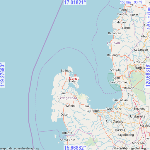
Carot GPS coordinates[2]
16° 20' 40.848" North, 119° 58' 48.18" East
| Map corner | latitude | longitude |
|---|---|---|
| Upper-left | 17.01821°, | 119.27693° |
| Center: | 16.34468°, | 119.98005° |
| Lower-right: | 15.66882°, | 120.68318° |
| Map W x H: | 150×150 km | = 93.2×93.2mi |
| max Lat: | 20.78733° ⇑9.8% North |
| Carot: | 16.34468° |
| min Lat: | ⇓90.2% South 4.65442° |
| min Long | Carot | max Long |
| 117.04868° | 119.98005° | 126.58417° |
| W 2.8%⇐ | ⇒97.2% E |
Elevation
Elevation of Carot is 8 m = 26 ft, and this is 79.9 m = 262 ft below average elevation for this country.
| Max E: |
2262 m = 7421 ft | 85.4% |
| Avg. | 87.9 m = 288 ft | |
| Carot | 8 m = 26 ft | |
Min E: |
-2 m = -7 ft | 14.6% |
See also: Philippines elevation on elevation.city.
Geographical zone
Carot is located in North Torrid zone (between Equator and Tropic of Cancer). Distance of this Northern Tropic circle is 788.6 km =490 mi to North.| Distance of | km | miles | from Carot |
|---|---|---|---|
| North Pole | 8189.7 | 5088.8 | to North |
| Arctic Circle | 5583.8 | 3469.6 | to North |
| Tropic Cancer | 788.6 | 490 | to North |
| Equator | 1817.4 | 1129.3 | to South |


Nearby cities:
15 places around Carot: (largest is in red/bold)
• Anda
7 km =4.3 mi,  207°
207°
• Balingasay
13.3 km =8.3 mi,  276°
276°
• Binabalian
10.1 km =6.3 mi,  326°
326°
• Bolinao
10.5 km =6.5 mi,  297°
297°
• Cabungan
1.7 km =1.1 mi,  108°
108°
• Catuday
19.4 km =12.1 mi,  252°
252°
• Lucap
17.3 km =10.7 mi,  172°
172°
• Lucero
9.9 km =6.2 mi,  312°
312°
• Pangapisan
14.5 km =9 mi,  189°
189°
• Polo
16.8 km =10.4 mi, 191°
• Sablig
8.5 km =5.3 mi, 174°
• Tiep
17.4 km =10.8 mi,  227°
227°
• Tondol
5.2 km =3.2 mi,  137°
137°
• Toritori
11.9 km =7.4 mi, 172°
• Zaragoza
6.1 km =3.8 mi,  321°
321°
Sources, notices
• [Note1] Compared only with cities in Philippines existing in our database
• [Src1] Map data: © OpenStreetMap contributors (CC-BY-SA)
• [Src2] Other city data from geonames.org with taken over terms of usage.
• [Src3] Geographical zone / Annual Mean Temperature by Robert A. Rohde @ Wikipedia
