San Vicente geodata
San Vicente (Davao) is a seat of a third-order administrative division; located in Philippines in Asia/Manila (GMT+8) time zone. In our database, there are 4166 cities with bigger population. Compared to other cities in Philippines, 84% of cities are located further ↑North; 96.6% of cities are located further ←West and 89.4% of cities have lower elevation than San Vicente. Note1


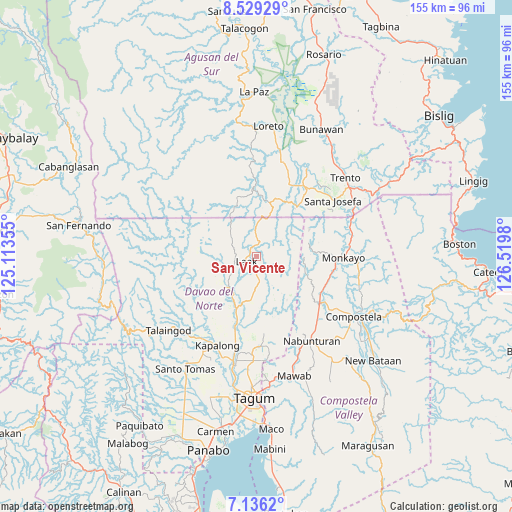
San Vicente GPS coordinates[2]
7° 49' 59.988" North, 125° 49' 0.012" East
| Map corner | latitude | longitude |
|---|---|---|
| Upper-left | 8.52929°, | 125.11355° |
| Center: | 7.83333°, | 125.81667° |
| Lower-right: | 7.1362°, | 126.5198° |
| Map W x H: | 154.9×154.9 km | = 96.3×96.3mi |
| max Lat: | 20.78733° ⇑84% North |
| San Vicente: | 7.83333° |
| min Lat: | ⇓16% South 4.65442° |
| min Long | San Vicente | max Long |
| 117.04868° | 125.81667° | 126.58417° |
| W 96.6%⇐ | ⇒3.4% E |
Elevation
Elevation of San Vicente is 216 m = 709 ft, and this is 128.1 m = 420 ft above average elevation for this country.
| Max E: |
2262 m = 7421 ft | 10.6% |
| San Vicente | 216 m 709 ft | |
| Avg. | 87.9 m = 288 ft | |
Min E: |
-2 m = -7 ft | 89.4% |
See also: Philippines elevation on elevation.city.
Geographical zone
San Vicente is located in North Torrid zone (between Equator and Tropic of Cancer). Distance of Equator is 871 km =541.2 mi to South.| Distance of | km | miles | from San Vicente |
|---|---|---|---|
| North Pole | 9136.1 | 5676.9 | to North |
| Arctic Circle | 6530.2 | 4057.7 | to North |
| Tropic Cancer | 1734.9 | 1078 | to North |
| Equator | 871 | 541.2 | to South |


Nearby cities:
15 places around San Vicente: (largest is in red/bold)
• Andop
7.6 km =4.7 mi,  294°
294°
• Baylo
26.4 km =16.4 mi,  84°
84°
• Cabinuangan
29.1 km =18.1 mi,  124°
124°
• Concepcion
14.8 km =9.2 mi,  231°
231°
• Gupitan
20.4 km =12.7 mi,  251°
251°
• Kaligutan
14.5 km =9 mi,  181°
181°
• Limbaan
21.5 km =13.4 mi, 178°
• Linoan
28.8 km =17.9 mi,  143°
143°
• Monkayo
26.3 km =16.3 mi,  94°
94°
• Montevista
24.5 km =15.2 mi,  129°
129°
• New Corella
27.4 km =17 mi, 178°
• Santa Josefa
29.3 km =18.2 mi,  53°
53°
• Sinubong
29 km =18 mi,  25°
25°
• Suz-on
27.3 km =17 mi, 226°
• Tapia
23.2 km =14.4 mi,  112°
112°
Sources, notices
• [Note1] Compared only with cities in Philippines existing in our database
• [Src1] Map data: © OpenStreetMap contributors (CC-BY-SA)
• [Src2] Other city data from geonames.org with taken over terms of usage.
• [Src3] Geographical zone / Annual Mean Temperature by Robert A. Rohde @ Wikipedia
