Mabilang geodata
Mabilang (Central Luzon) is a populated place; located in Philippines in Asia/Manila (GMT+8) time zone. With population of 2,229 people, there are 3829 cities with bigger population in this country. Compared to other cities in Philippines, 83.6% of cities are located further ↓South; 91% of cities are located further →East and 54.4% of cities have lower elevation than Mabilang. Note1


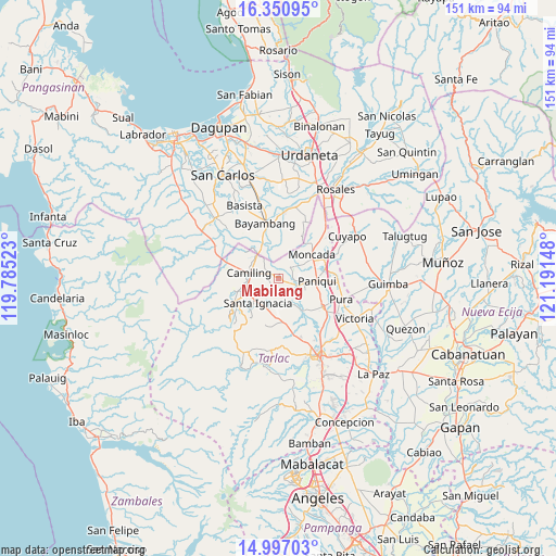
Mabilang GPS coordinates[2]
15° 40' 30.396" North, 120° 29' 18.06" East
| Map corner | latitude | longitude |
|---|---|---|
| Upper-left | 16.35095°, | 119.78523° |
| Center: | 15.67511°, | 120.48835° |
| Lower-right: | 14.99703°, | 121.19148° |
| Map W x H: | 150.5×150.5 km | = 93.5×93.5mi |
| max Lat: | 20.78733° ⇑16.4% North |
| Mabilang: | 15.67511° |
| min Lat: | ⇓83.6% South 4.65442° |
| min Long | Mabilang | max Long |
| 117.04868° | 120.48835° | 126.58417° |
| W 9%⇐ | ⇒91% E |
Elevation
Elevation of Mabilang is 27 m = 89 ft, and this is 60.9 m = 200 ft below average elevation for this country.
| Max E: |
2262 m = 7421 ft | 45.6% |
| Avg. | 87.9 m = 288 ft | |
| Mabilang | 27 m = 89 ft | |
Min E: |
-2 m = -7 ft | 54.4% |
See also: Philippines elevation on elevation.city.
Geographical zone
Mabilang is located in North Torrid zone (between Equator and Tropic of Cancer). Distance of this Northern Tropic circle is 863 km =536.2 mi to North.| Distance of | km | miles | from Mabilang |
|---|---|---|---|
| North Pole | 8264.2 | 5135.1 | to North |
| Arctic Circle | 5658.3 | 3515.9 | to North |
| Tropic Cancer | 863 | 536.2 | to North |
| Equator | 1742.9 | 1083 | to South |


Nearby cities:
15 places around Mabilang: (largest is in red/bold)
• Bacabac
8.5 km =5.3 mi,  310°
310°
• Balaoang
3.1 km =1.9 mi,  114°
114°
• Baquero Norte
8.4 km =5.2 mi,  57°
57°
• Bilad
9 km =5.6 mi,  319°
319°
• Cabayaoasan
6.9 km =4.3 mi,  101°
101°
• Camiling
8.2 km =5.1 mi,  278°
278°
• Malacampa
9 km =5.6 mi,  246°
246°
• Nambalan
9 km =5.6 mi,  199°
199°
• Nancamarinan
5.1 km =3.2 mi,  89°
89°
• San Francisco
7.6 km =4.7 mi,  227°
227°
• Santa Ignacia
8.6 km =5.3 mi,  221°
221°
• Santa Maria
7.5 km =4.7 mi,  242°
242°
• Sapang
5 km =3.1 mi,  51°
51°
• Sinilian First
3.7 km =2.3 mi,  303°
303°
• Vargas
9.1 km =5.7 mi,  180°
180°
Sources, notices
• [Note1] Compared only with cities in Philippines existing in our database
• [Src1] Map data: © OpenStreetMap contributors (CC-BY-SA)
• [Src2] Other city data from geonames.org with taken over terms of usage.
• [Src3] Geographical zone / Annual Mean Temperature by Robert A. Rohde @ Wikipedia
