Balaoang geodata
Balaoang (Central Luzon) is a populated place; located in Philippines in Asia/Manila (GMT+8) time zone. With population of 3,724 people, there are 1901 cities with bigger population in this country. Compared to other cities in Philippines, 83.5% of cities are located further ↓South; 90.6% of cities are located further →East and 51.1% of cities have lower elevation than Balaoang. Note1


Balaoang GPS coordinates[2]
15° 39' 47.88" North, 120° 30' 52.92" East
| Map corner | latitude | longitude |
|---|---|---|
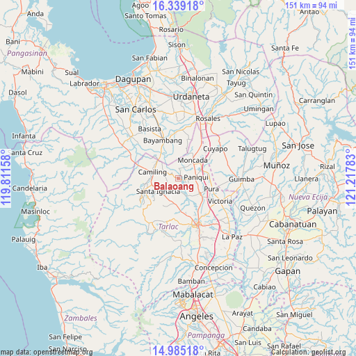
| Upper-left | 16.33918°, | 119.81158° |
| Center: | 15.6633°, | 120.5147° |
| Lower-right: | 14.98518°, | 121.21783° |
| Map W x H: | 150.6×150.6 km | = 93.6×93.6mi |
| max Lat: | 20.78733° ⇑16.5% North |
| Balaoang: | 15.6633° |
| min Lat: | ⇓83.5% South 4.65442° |
| min Long | Balaoang | max Long |
| 117.04868° | 120.5147° | 126.58417° |
| W 9.4%⇐ | ⇒90.6% E |
Elevation
Elevation of Balaoang is 24 m = 79 ft, and this is 63.9 m = 210 ft below average elevation for this country.
| Max E: |
2262 m = 7421 ft | 48.9% |
| Avg. | 87.9 m = 288 ft | |
| Balaoang | 24 m = 79 ft | |
Min E: |
-2 m = -7 ft | 51.1% |
See also: Philippines elevation on elevation.city.
Geographical zone
Balaoang is located in North Torrid zone (between Equator and Tropic of Cancer). Distance of this Northern Tropic circle is 864.3 km =537.1 mi to North.| Distance of | km | miles | from Balaoang |
|---|---|---|---|
| North Pole | 8265.5 | 5135.9 | to North |
| Arctic Circle | 5659.6 | 3516.7 | to North |
| Tropic Cancer | 864.3 | 537.1 | to North |
| Equator | 1741.6 | 1082.2 | to South |


Nearby cities:
15 places around Balaoang: (largest is in red/bold)
• Baquero Norte
7.3 km =4.5 mi,  35°
35°
• Buenlag
8.2 km =5.1 mi,  118°
118°
• Burgos
9.5 km =5.9 mi, 40°
• Cabayaoasan
3.9 km =2.4 mi,  90°
90°
• Mabilang
3.1 km =1.9 mi,  294°
294°
• Moncada
10.2 km =6.3 mi, 38°
• Nambalan
9.2 km =5.7 mi,  219°
219°
• Nancamarinan
2.7 km =1.7 mi,  60°
60°
• Paniqui
7.1 km =4.4 mi,  84°
84°
• San Francisco
9.2 km =5.7 mi,  245°
245°
• Santa Ignacia
9.9 km =6.2 mi,  238°
238°
• Santa Maria
9.7 km =6 mi,  256°
256°
• Sapang
4.6 km =2.9 mi,  13°
13°
• Sinilian First
6.8 km =4.2 mi,  299°
299°
• Vargas
8.3 km =5.2 mi,  200°
200°
Sources, notices
• [Note1] Compared only with cities in Philippines existing in our database
• [Src1] Map data: © OpenStreetMap contributors (CC-BY-SA)
• [Src2] Other city data from geonames.org with taken over terms of usage.
• [Src3] Geographical zone / Annual Mean Temperature by Robert A. Rohde @ Wikipedia
