Bagacay geodata
Bagacay (Central Visayas) is a populated place; located in Philippines in Asia/Manila (GMT+8) time zone. With population of 2,190 people, there are 3905 cities with bigger population in this country. Compared to other cities in Philippines, 69.7% of cities are located further ↑North; 69.6% of cities are located further ←West and 94.3% of cities have lower elevation than Bagacay. Note1


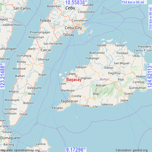
Bagacay GPS coordinates[2]
9° 51' 59.04" North, 123° 55' 4.8" East
| Map corner | latitude | longitude |
|---|---|---|
| Upper-left | 10.55838°, | 123.21488° |
| Center: | 9.8664°, | 123.918° |
| Lower-right: | 9.17296°, | 124.62113° |
| Map W x H: | 154×154 km | = 95.7×95.7mi |
| max Lat: | 20.78733° ⇑69.7% North |
| Bagacay: | 9.8664° |
| min Lat: | ⇓30.3% South 4.65442° |
| min Long | Bagacay | max Long |
| 117.04868° | 123.918° | 126.58417° |
| W 69.6%⇐ | ⇒30.4% E |
Elevation
Elevation of Bagacay is 385 m = 1263 ft, and this is 297.1 m = 975 ft above average elevation for this country.
| Max E: |
2262 m = 7421 ft | 5.7% |
| Bagacay | 385 m 1263 ft | |
| Avg. | 87.9 m = 288 ft | |
Min E: |
-2 m = -7 ft | 94.3% |
See also: Philippines elevation on elevation.city.
Geographical zone
Bagacay is located in North Torrid zone (between Equator and Tropic of Cancer). Distance of Equator is 1097 km =681.6 mi to South.| Distance of | km | miles | from Bagacay |
|---|---|---|---|
| North Pole | 8910 | 5536.4 | to North |
| Arctic Circle | 6304.1 | 3917.2 | to North |
| Tropic Cancer | 1508.9 | 937.6 | to North |
| Equator | 1097 | 681.6 | to South |


Nearby cities:
15 places around Bagacay: (largest is in red/bold)
• Abucayan
7 km =4.3 mi,  356°
356°
• Antequera
9.7 km =6 mi,  192°
192°
• Balilihan
13.7 km =8.5 mi,  153°
153°
• Bood
16.7 km =10.4 mi,  216°
216°
• Calape
5.5 km =3.4 mi,  301°
301°
• Catigbian
9.1 km =5.7 mi,  101°
101°
• Clarin
15.8 km =9.8 mi,  47°
47°
• Cortes
16.6 km =10.3 mi, 194°
• Loon
15.6 km =9.7 mi,  241°
241°
• Maribojoc
16 km =9.9 mi,  210°
210°
• Nahawan
18.4 km =11.4 mi, 50°
• Panaytayon
11.7 km =7.3 mi,  37°
37°
• Pinayagan Norte
8.2 km =5.1 mi,  25°
25°
• San Isidro
6.8 km =4.2 mi,  325°
325°
• Tibigan
10.7 km =6.6 mi, 27°
Sources, notices
• [Note1] Compared only with cities in Philippines existing in our database
• [Src1] Map data: © OpenStreetMap contributors (CC-BY-SA)
• [Src2] Other city data from geonames.org with taken over terms of usage.
• [Src3] Geographical zone / Annual Mean Temperature by Robert A. Rohde @ Wikipedia
