San Isidro geodata
San Isidro (Central Visayas) is a seat of a third-order administrative division; located in Philippines in Asia/Manila (GMT+8) time zone. With population of 9,125 people, there are 675 cities with bigger population in this country. Compared to other cities in Philippines, 69.2% of cities are located further ↑North; 69.2% of cities are located further ←West and 98.8% of cities have higher elevation than San Isidro. Note1


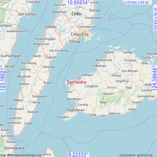
San Isidro GPS coordinates[2]
9° 55' 0.012" North, 123° 52' 59.988" East
| Map corner | latitude | longitude |
|---|---|---|
| Upper-left | 10.60854°, | 123.18021° |
| Center: | 9.91667°, | 123.88333° |
| Lower-right: | 9.22333°, | 124.58646° |
| Map W x H: | 154×154 km | = 95.7×95.7mi |
| max Lat: | 20.78733° ⇑69.2% North |
| San Isidro: | 9.91667° |
| min Lat: | ⇓30.8% South 4.65442° |
| min Long | San Isidro | max Long |
| 117.04868° | 123.88333° | 126.58417° |
| W 69.2%⇐ | ⇒30.8% E |
Elevation
Elevation of San Isidro is 2 m = 7 ft, and this is 85.9 m = 282 ft below average elevation for this country.
| Max E: |
2262 m = 7421 ft | 98.8% |
| Avg. | 87.9 m = 288 ft | |
| San Isidro | 2 m = 7 ft | |
Min E: |
-2 m = -7 ft | 1.2% |
See also: Philippines elevation on elevation.city.
Geographical zone
San Isidro is located in North Torrid zone (between Equator and Tropic of Cancer). Distance of Equator is 1102.6 km =685.1 mi to South.| Distance of | km | miles | from San Isidro |
|---|---|---|---|
| North Pole | 8904.4 | 5532.9 | to North |
| Arctic Circle | 6298.5 | 3913.7 | to North |
| Tropic Cancer | 1503.3 | 934.1 | to North |
| Equator | 1102.6 | 685.1 | to South |


Nearby cities:
15 places around San Isidro: (largest is in red/bold)
• Abucayan
3.7 km =2.3 mi,  68°
68°
• Antequera
15.2 km =9.4 mi,  173°
173°
• Bagacay
6.8 km =4.2 mi,  145°
145°
• Balilihan
20.4 km =12.7 mi, 151°
• Bood
20 km =12.4 mi,  197°
197°
• Calape
2.9 km =1.8 mi, 198°
• Catigbian
14.7 km =9.1 mi,  120°
120°
• Clarin
16.3 km =10.1 mi, 72°
• Cortes
21.6 km =13.4 mi,  180°
180°
• Loon
16.3 km =10.1 mi,  217°
217°
• Maribojoc
19.9 km =12.4 mi,  192°
192°
• Nahawan
19.1 km =11.9 mi, 71°
• Panaytayon
11.6 km =7.2 mi, 71°
• Pinayagan Norte
7.5 km =4.7 mi,  75°
75°
• Tibigan
9.5 km =5.9 mi, 65°
Sources, notices
• [Note1] Compared only with cities in Philippines existing in our database
• [Src1] Map data: © OpenStreetMap contributors (CC-BY-SA)
• [Src2] Other city data from geonames.org with taken over terms of usage.
• [Src3] Geographical zone / Annual Mean Temperature by Robert A. Rohde @ Wikipedia
