Calape geodata
Calape (Central Visayas) is a seat of a third-order administrative division; located in Philippines in Asia/Manila (GMT+8) time zone. With population of 3,367 people, there are 2173 cities with bigger population in this country. Compared to other cities in Philippines, 69.5% of cities are located further ↑North; 69.1% of cities are located further ←West and 85.4% of cities have higher elevation than Calape. Note1


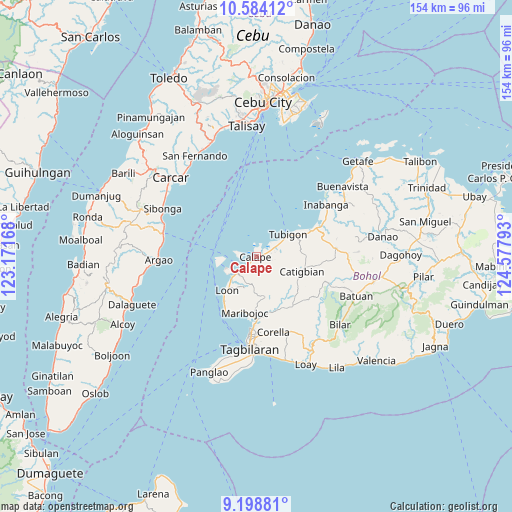
Calape GPS coordinates[2]
9° 53' 31.92" North, 123° 52' 29.28" East
| Map corner | latitude | longitude |
|---|---|---|
| Upper-left | 10.58412°, | 123.17168° |
| Center: | 9.8922°, | 123.8748° |
| Lower-right: | 9.19881°, | 124.57793° |
| Map W x H: | 154×154 km | = 95.7×95.7mi |
| max Lat: | 20.78733° ⇑69.5% North |
| Calape: | 9.8922° |
| min Lat: | ⇓30.5% South 4.65442° |
| min Long | Calape | max Long |
| 117.04868° | 123.8748° | 126.58417° |
| W 69.1%⇐ | ⇒30.9% E |
Elevation
Elevation of Calape is 8 m = 26 ft, and this is 79.9 m = 262 ft below average elevation for this country.
| Max E: |
2262 m = 7421 ft | 85.4% |
| Avg. | 87.9 m = 288 ft | |
| Calape | 8 m = 26 ft | |
Min E: |
-2 m = -7 ft | 14.6% |
See also: Philippines elevation on elevation.city.
Geographical zone
Calape is located in North Torrid zone (between Equator and Tropic of Cancer). Distance of Equator is 1099.9 km =683.4 mi to South.| Distance of | km | miles | from Calape |
|---|---|---|---|
| North Pole | 8907.2 | 5534.7 | to North |
| Arctic Circle | 6301.3 | 3915.4 | to North |
| Tropic Cancer | 1506 | 935.8 | to North |
| Equator | 1099.9 | 683.4 | to South |


Nearby cities:
15 places around Calape: (largest is in red/bold)
• Abucayan
6 km =3.7 mi,  46°
46°
• Antequera
12.7 km =7.9 mi,  168°
168°
• Bagacay
5.5 km =3.4 mi,  121°
121°
• Balilihan
18.6 km =11.6 mi,  144°
144°
• Bood
17.1 km =10.6 mi,  197°
197°
• Catigbian
14.4 km =8.9 mi,  108°
108°
• Clarin
18.2 km =11.3 mi,  64°
64°
• Cortes
18.9 km =11.7 mi,  178°
178°
• Loon
13.6 km =8.5 mi,  221°
221°
• Maribojoc
17.1 km =10.6 mi,  191°
191°
• Nahawan
20.9 km =13 mi,  65°
65°
• Panaytayon
13.5 km =8.4 mi, 61°
• Pinayagan Norte
9.4 km =5.8 mi, 60°
• San Isidro
2.9 km =1.8 mi,  18°
18°
• Tibigan
11.6 km =7.2 mi, 55°
Sources, notices
• [Note1] Compared only with cities in Philippines existing in our database
• [Src1] Map data: © OpenStreetMap contributors (CC-BY-SA)
• [Src2] Other city data from geonames.org with taken over terms of usage.
• [Src3] Geographical zone / Annual Mean Temperature by Robert A. Rohde @ Wikipedia
