Banaba geodata
Banaba (Calabarzon) is a populated place; located in Philippines in Asia/Manila (GMT+8) time zone. With population of 4,387 people, there are 1543 cities with bigger population in this country. Compared to other cities in Philippines, 72.1% of cities are located further ↓South; 81% of cities are located further →East and 89.8% of cities have lower elevation than Banaba. Note1


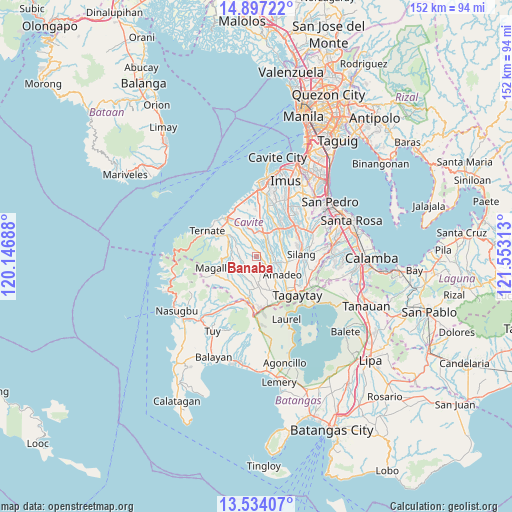
Banaba GPS coordinates[2]
14° 13' 0.012" North, 120° 51' 0" East
| Map corner | latitude | longitude |
|---|---|---|
| Upper-left | 14.89722°, | 120.14688° |
| Center: | 14.21667°, | 120.85° |
| Lower-right: | 13.53407°, | 121.55313° |
| Map W x H: | 151.6×151.6 km | = 94.2×94.2mi |
| max Lat: | 20.78733° ⇑27.9% North |
| Banaba: | 14.21667° |
| min Lat: | ⇓72.1% South 4.65442° |
| min Long | Banaba | max Long |
| 117.04868° | 120.85° | 126.58417° |
| W 19%⇐ | ⇒81% E |
Elevation
Elevation of Banaba is 223 m = 732 ft, and this is 135.1 m = 443 ft above average elevation for this country.
| Max E: |
2262 m = 7421 ft | 10.2% |
| Banaba | 223 m 732 ft | |
| Avg. | 87.9 m = 288 ft | |
Min E: |
-2 m = -7 ft | 89.8% |
See also: Philippines elevation on elevation.city.
Geographical zone
Banaba is located in North Torrid zone (between Equator and Tropic of Cancer). Distance of this Northern Tropic circle is 1025.2 km =637 mi to North.| Distance of | km | miles | from Banaba |
|---|---|---|---|
| North Pole | 8426.3 | 5235.9 | to North |
| Arctic Circle | 5820.4 | 3616.6 | to North |
| Tropic Cancer | 1025.2 | 637 | to North |
| Equator | 1580.7 | 982.2 | to South |


Nearby cities:
15 places around Banaba: (largest is in red/bold)
• Alfonso
8.4 km =5.2 mi,  177°
177°
• Aliang
8.2 km =5.1 mi,  25°
25°
• Amadeo
9.4 km =5.8 mi,  122°
122°
• Batas
4 km =2.5 mi,  242°
242°
• Bitangan
5.1 km =3.2 mi,  36°
36°
• General Emilio Aguinaldo
6.9 km =4.3 mi, 238°
• Guyam Malaki
7.2 km =4.5 mi,  170°
170°
• Indang
3.8 km =2.4 mi,  129°
129°
• Javalera
8.4 km =5.2 mi,  56°
56°
• Malainen Luma
8.9 km =5.5 mi,  311°
311°
• Matagbak
9.7 km =6 mi,  189°
189°
• Palangue
8.6 km =5.3 mi,  330°
330°
• Pangil
6.5 km =4 mi,  105°
105°
• Pantijan No 2
5.6 km =3.5 mi,  288°
288°
• Taywanak Ilaya
6.6 km =4.1 mi, 183°
Sources, notices
• [Note1] Compared only with cities in Philippines existing in our database
• [Src1] Map data: © OpenStreetMap contributors (CC-BY-SA)
• [Src2] Other city data from geonames.org with taken over terms of usage.
• [Src3] Geographical zone / Annual Mean Temperature by Robert A. Rohde @ Wikipedia
